Why doesn't Garmin Explore in my browser show the detailed track of my InReach as it does in my iOS Explore app?

Hi all,

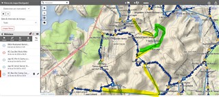
When I look at tracks in a collection on Garmin Explore web, it only shows straight lines connecting the points sent by my InReach Mini 2 on the day I was walking. 

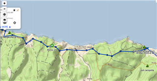
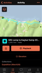
On the iOS Explore app, it shows the detailed tracking (which I enabled on the device) which is what I want to see for exporting purposes, on Garmin Explore web.

Any help would be appreciated.

Thanks a ton, 

Marcell

  • Ok but if I created an a new collection with only one item there should be nothing else to filter 

  • I tried to provide you with something to try out to answer your question on how courses are displayed. From your screenshots it's difficult to tell if the selected course is displayed correctly, because all items in your library are displayed.

    And if you have an inReach capable device, it could also very well be that the points connected with straight lines are not courses but the track logs you tracked with the inReach capable device. These should be listed in your library under Tracks, are indicated as lines with circles for each track point. See Getting Started With the Garmin Explore Website Map Page for more information.

  • Tks for the article. I can now understand how it "should" work.

    1) filters turned off (show everything)

    2) Category "Track" set to show 

    3) Nonetheless tracks are not showed on the map even with filters off, category=show, track=show...

    Regards,

  • Wow,

    I've just found part of the solution. (how to show tracks)

    Turns out there was one more "layer" (call it what you want). 

    Toggling Track Visibility

    By default, all tracks are set to appear on the map tab of the Garmin Explore website. If your track summary appears in the library, but does not appear on the map when selected, you may need to toggle the visibility on.

    1. Select   to center the map on the user.

    2. Select   so that the track expands.

    Once this is done, the icon should now be  .

    Now I'm just missing to find out the straight lines.

    Grewn highlighted = course

    Yellow highlighted -> straight lines = route?

    Blue triangles = track

  • Do you have an inReach capable device (if you do, which one?) and have you used tracking? If so then the yellow highlighted paths are inReach track logs (where your location is sent in intervals via Iridium satellite network). These are identified with the lines and the small circles, the circles are the track points.

  • No, I have a Fenix 7x Pro SS.

    I can recreate this at any moment.

    1) create a course (not a Track) with or without cue_points(turn-by-turns & warnings)  using any online tool (RWGPS, komoot, PlotaRoute, you name it)

    2) Send the fit file via USB cable directly to the folder Garmin\NewFiles files

    3) You will end up with a course that you can navigate with up Ahead list, tbt, warnings whatever you have incuded.

    4) after you sync GE iOS will show you only the course while the GEW will show the course AND the straight lines we have been talking about.

  • Ah well that is strange then, I do not have a direct explanation for that behavior.

    Do the circles on the straight line correspond to the waypoints you used when creating the course? And can you share an example of a FIT file for which this happens? And what happens if you import the FIT file you get from step 1 directly into Garmin Explore iOS app and then sync?

  • Love the question!!!

    Because UNFORTUNATELY and unbelievably UNEXPLAINED GE does not support importing  .fit or .tcx files but only GPX, KML  and KMZ files...

  • ah yeah you're right, I forgot that Explore does not support importing FIT files. well not sure I can help you further then... maybe someone else can

  • Hello, this is possibly happening because you are taking a .FIT file and moving it to the website which does not support .FIT files. Please see Importing Waypoints, Routes, and Tracks Into the Garmin Explore Website. In the Important Notes section you'll see more details about the conversion of the file types. This most likely is the case. 

    • Turn by turn routes created from waypoints in BaseCampTm software will only show straight lines between points once imported into the Garmin Explore website. To prevent this issue and preserve the route detail, convert the route into a track in the BaseCamp software, then import the track into the Garmin Explore website. For detailed steps, see - BaseCamp (PC): Creating a Track from a Route or BaseCamp (Mac): Creating a Track from a Route.