This discussion has been locked.
You can no longer post new replies to this discussion. If you have a question you can start a new discussion

XT2 gives straight line routing over rivers when route created using Explore.

Created a route on Explore.  Easy loop on roads in Motorcycle mode.  Synced with brand new XT2.  Some of the route is fine, but then there are parts where the route becomes a straight line - over a creek (not in the attached pictures)   
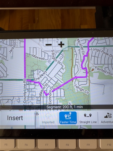
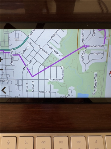
and over land - NO trail, just land and a creek. Attached is a photo of the route on my XT2.  I have NO avoidances on.

  • I don't have an XT2, but I do know that the Explore website map doesn't have "snap to fit" capability. It only connects points you specify with straight lines. It doesn't automatically fit the points to the shape of the road. Yet, I see you have some curvy lines in the photo. I'm guessing that maybe the XT2 did some of that. I don't know for sure that's the problem, but it could be.

    The terminology is also confusing. A "route" in the automotive GPS world is calculated by the GPS, based on your current location and a destination you define.  A "route" in the hiking GPS world was defined by the user using map software, to click point by point the intended path, with the final point being the destination. The Explore webpage was originally used only in the hiking world.

  • So, the Explore website is new to me.  I've used Basecamp for many years, and Mapsource (which preceeded Basecamp).  Yes, the GPS is supposed to create the route (calculates it), but it's supposed to use ROADS for the most part.  It can use dirt roads, ferries, etc., but this is just ridiculous.  Explore is what Garmin tells me to use now, because Basecamp is "not supported" using the XT2.  Explore (at least on my M1 Mac Studio) is not in very good shape.  MANY issues, some I've talked to Garmin about.  BTW, a route is supposed to go from a starting point, through via points, waypoints and then to the destination.  So, I am supposed to be able to create routes that the GPS calculates through the points.  Sometimes it work, MANY times is doesn't.  It's just the Garmin way these days. I'm hoping Garmin actually looks at these posts and has some feedback.  Thanks.

  • Yes, the Explore web map is in need of updating. The routing on the website doesn't calculate anything, you just click point by point and it connects using straight lines. The Explore phone app does have snap to fit.

    You could go to a third party mapping website, and download the route you create there onto your computer. Then, import that file into the Explore website, and then synch the XT2 with the Explore website. However, the Explore website limits Routes to 200 data points, which may be too restrictive, especially for a motorcycle trip.

    You could do this with the Garmin Connect website too. It has a good map. I don't think the XT2 can synch off of Connect directly (it was originally for fitness watches, but my hiking device can synch to it), so you would have to export and then import into Explore. And if more than 200 points (ie coordinates) it won't import as a route.