"Network Error" popup message when trying to create courses on trails in remote settings (no WiFi or cell available)

While hiking in a remote wilderness location, I had no success creating courses that followed trails.  Prior to the trip when I still had internet connectivity, I was able to create courses that followed these same trails so I know that the Explore topoactive map recognized the existence of the trails of interest.  However, I could not create a course once I was out in the woods, even when I tried to duplicate the exact same course I had made previously. 

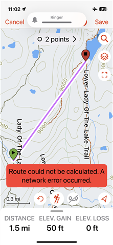
What happened is that I was able to enter the first point, but when I then attempted to add the 2nd point, the app drew a straight purple line between the 2 points (didn't follow the trail) and a red popup message appeared saying "Route could not be calculated.  A network error occurred."  (I'll try to attach an screenshot image to make this clearer).  Interestingly, once back at home, I find that I get the same behavior and same message if I try to create a course with my iPhone in airplane mode.

Can Explore only create courses when it has connectivity?  If so, I don't get it because the ability to make courses in the field is an important feature.  Or is there perhaps some setting I'm overlooking that would circumvent the network error/direct line issue?

  • I tried creating a course with my phone in airplane mode, and I indeed also get the same error. Agree that needing internet connectivity when creating a course kind of defeats the purpose of the Explore app.

    The Creating Courses in the Garmin Explore App explicitly states that courses can be created offline, so this is probably a bug? But to be honest I cannot remember whether creating courses when offline used to work with earlier versions of the new Explore app.

    Edit: uninstalling and reinstalling the Explore app solved the issue for me. But that kind of sucks when you're out on a trip. Garmin should test this stuff better.

  • That's good (well, not really!) that you got the same behavior, so I know it's not just me.

    I'm trying to rely more heavily on courses, instead of traditional tracks, for navigation in my 67i but I've had a fair amount of difficulty figuring out how it all works: creating tracks in Explore, syncing to the 67i, and then using them in the field.  It is a VERY common task for those of us that hike in remote areas to want to create a course on the fly and then navigate it while seeing the upcoming distances to waypoints, the elevation profile from the current location onwards, etc.  Courses are ideally suited for all that, but I rarely know enough in advance of a trip to build all of the possible courses I might want to (or need to) later navigate.

    Interesting that the re-install fixed it.  I guess I should try that -- will I lose any saved data (collections, waypoints, etc) or will those reload neatly from the cloud or wherever the data lives?

    The other thing I learned on my recent trip is that there is apparently no option to simply reverse a course and navigate back.  An old thread here said that the work-around is to save the course as a track and then copy/reverse the track.  However, navigating a track doesn't provide the same information as navigating a course (no on-trail distance to next waypoint, etc).  So that is another obvious missing feature.

  • Note that in Explore app you can only create courses, and not tracks. But you can import tracks from GPX files, those will end up as tracks in Explore. And to make things complicated, Explore web only supports creating tracks and routes…

    As for the reinstall, if you sync your data before you delete the app, all your data is kept in the cloud and synced back when you start the app after installing. You can trigger this sync from the menu you get when clicking your profile picture on the map screen, and then press the sync icon.

    Directly reversing a course is indeed not possible. But if you just want to navigate back the path you have taken during an activity, you can also use the TracBack function of the GPSMAP 67I. This is accessed by going to Recording Controls (see main menu), go the map tab by pressing right, and then select TracBack.

  • In the past, I always just created tracks in Basecamp by clicking through the desired path.  Laborious at best, so I was delighted when I learned that in Explore I could simply select the Roads/Trails option, click on a few key waypoints, and presto! -- it drew the lines without my having to click in a hundred points!  I've pretty much given up on Explore web because of what you said (routes rather than courses) and it seems that Garmin doesn't have much interest in updating it either.

    I know about TracBack but haven't used it except a few quick tests.  I recall that in the inReach Mini2, TracBack was possible even if you didn't have Recording turned on.  Apparently, the Mini2 kept a hidden breadcrumb log in memory that contained enough points to navigate back.  Is that also true in the 67i?  I generally record my outbound track, but sometimes I forget to turn Recording on.

  • You can configure the GPSMAP 67i to auto start recording an activity when it is turned on and has a good satellite fix. But personally I do not use that and always manually start recording when starting my hike. It is a simple double press of the Enter key on most pages. This also makes TracBack work well because it will navigate you back to the point where you started your activity recording, e.g. the trailhead.

    And for planning courses, I mainly use Komoot and then either use the Komoot ConnectIQ app to download the course to the GPSMAP or I export the GPX manually on my phone and import it into the Explore app.

    One big downside though is that GPX files do not support course points, so importing a GPX into Explore app won’t give course points. So far the only solution I have found is to use a planning tool that exports FIT files (like RideWithGPS or Footpath app) and copy the file to the GPSMAP 67i internal storage. And planning platforms that integrate with Connect also won’t give course points because the Connect sync strips those out.

  • Now that I've starting using courses, I'm kind of hooked on the course point system.  I really like being able to flip to the Active Route page and see the on-trail distances to the next named point and all points thereafter.  I think the most common question that comes up while hiking is "How much further to the lake (or the trail junction, peak, etc)?"  The listing of the upcoming course points and distances on the Active Route page is invaluable for that.  I flip back and forth between the map page and the Active Route page pretty often.

    I've had decent success creating courses in advance in Explore; but not so much on the 67i device itself.  Creating a course in the Course Planner of the 67i gives the options to use the map or use waypoints.  I can (usually) get it to work using pre-designated waypoints, but using the map is maddening.  I can't figure out how to get it to scroll to the next location without it prematurely dropping in a point where I don't want one.  I don't know how the "use map" option is supposed to work, but it seems random and fiddly.

  • A couple more notes about this issue (inability to snap to roads/trails when offline):

    A user in one of the 67i FB forums stated that in Explore iOs "courses and routes require connectivity to snap to path...".  I think he may be right about that because I still couldn't get it work after a reinstall. 

    In contrast, Gaia (and maybe other apps) DO have this functionality.  In Gaia, you toggle on the "Offline Route Data" option when downloading offline maps and then the app has the necessary data to snap to roads/trails with no connectivity.  That is (for me at least) a huge advantage because this is such a common need in wilderness settings.

  • You should contact support then, because according to the support rep I spoke to the Explore app should support offline routing with roads & trails being followed. It also works for me now with my phone in airplane mode (and of course offline maps downloaded before hand).

  • Dang -- this makes me wonder again if it's some obscure iPhone setting that's mucking things up for me.  I'll keep at it!

  • Did you delete the app from your phone and install it again? You can easily test by downloading offline maps for a region and then turning airplane mode on before creating a course.