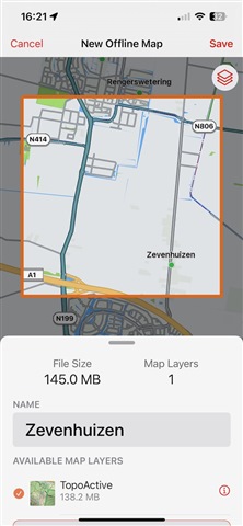
I just updated the iOS app to the new version. I tried downloading an offline map, but it looks like there are no free maps any more? It looks like I can only use offline maps if I purchase the Outdoor Maps+ subscription. Is this correct??
I just updated the iOS app to the new version. I tried downloading an offline map, but it looks like there are no free maps any more? It looks like I can only use offline maps if I purchase the Outdoor Maps+ subscription. Is this correct??
It actually allowed me to “Save” the Tokyo offline map, with 0 layers 0 bytes.
then when I went back to get screenshots the app crashed just afterwards
After the last update Garmin support got in touch again and on their advice I reinstalled the app, and I can now download the topoactive and satellite layers for Japan maps, all happy now, problem solved…
Looks like that without an Outdoor Maps+ subscription you get TopoActive maps (called Topo in the app), satellite imagery and the basemap. You also get access to Relief Shading, Contour Lines (SD) and Hiking Popularity layers. At least that's what the app shows for my location in Europe.
The maps can be downloaded for offline use, Outdoor Maps+ is not needed for that.
If you check the Map Settings (click profile picture, select Map Settings) there's an option to Auto Download maps. The app will just stream the selected map layer (layers icon on map screen) for your current location.
You can download Offline Maps by going to the Offline Maps tab, and clicking the New Offline Map button. Then you can select the area for which you want to download the maps, and you can select the layers you want to download.
Another option to download option maps is to select a Course, Route or Track from your Saved library, click the three dots and select Create Offline Map. This will pre-select the area of the Course/Route/Track for downloading maps.
How did you access that screen? Looks like you're trying to edit an offline map instead of adding a new one?
This is what I see when I go to Offline Maps in the tab bar and click the New Offline Map button. This is on a Garmin account without an Outdoor Maps+ subscription.

The hiking popularity layer is a kind of heat map that shows what the popular roads and trails are for hiking. The more intense the color on the map, the more popular that road or trail is. The data is coming from activities that have been recorded with Garmin devices and have been uploaded to Garmin's server.
Not sure if Garmin Explore app will also take this information into account when creating a new Course. Connect does have this feature though.
Interesting! So I assume that when I see a trail no longer displayed when I click that layer "on" that means it gets less traffic. I'll have to zoom in more to see if it is actually displayed as a different color or is gone altogether. I haven't tried creating a course in Connect but I'll tinker around with it in Explore to see if it can use the Popularity data when creating courses.
As an aside, I saw some complaints that the offline sat images and USGS quads were no longer free in the Explore update. I'm not sure if that is correct, but I do see the sat images now. It's not clear to me whether those will still be visible offline in a remote location.