This discussion has been locked.
You can no longer post new replies to this discussion. If you have a question you can start a new discussion

App Garmin Explore: the total ascent is not correct

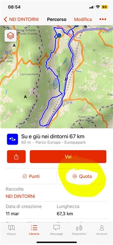
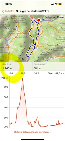
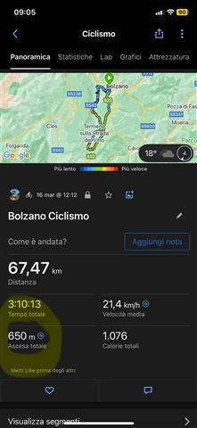
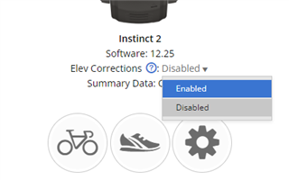
When I create a route with Garmin Explore the total ascent is not correct, but it's almost the double. What do I do wrong? Thanks

  • Hello, can you maybe provide the steps you are taking to create the route and then where you are looking at to see total ascent? What are you comparing it to to know it is wrong? Can you also provide pictures of the errors you are seeing with total ascent? 

  • Hi, here the steps. I start by selecting the start (green colored dor) and then I create the whole route drawing with a finger a sequence of dots until the last one, back to the start (it was a ring). I made a test riding my bike on a well known route, and comparing the final data (I used my Garmin 67i and the app Connect) with the ones calculated by the app Explore. You can look at the pictures below.

    As you can see the total lenght of the ride is the same between estimated route (Explore) and the actual one (Garmin 67i and Connect). Where the data differ is the total ascent. Estimated one 1240 m, actual one 650 m.

    Where is the problem?

    Thank you!!!!

  • Where is the problem?

    Could you share links to the course and to the activity? Please make them both public in Garmin Connect. Easier done in Garmin Connect Web at https://connect.garmin.com/modern/courses and at https://connect.garmin.com/modern/activities 

    Also please try temporarily enabling the Elevation Corrections on the right side of the activity page (under the device logo) in GC Web, and tell us what the Elevation Gain reports then. Just to exclude that the altimeter misbehaved. 

  • I do not see ascent in the explore app I only get "climbing elevation" so I am not sure where the disconnect is between your app and mine. However, it could be that in the explore app its ascent and in connect its total ascent which can give two different numbers. Total Ascent, Average Ascent, and Maximum Elevation

  • The Total Ascent calculated by the GPSMAP 67i is very inaccurate when the altimeter is set to Auto Calibrate. So I would not assume that the Total Ascent reported on an activity recorded with the 67i represents the actual total elevation.

    So I would do what trux suggested: check what Connect reports as total elevation when you enable corrected elevation.

  • Well, I'd never use corrected elevation, specially on mountain regions. It is dependable of a good DEM info which is not always the case around the world.

    There has not been a single time where corrected elevation, for the same fit file, agreed among Google Earth, Strava, Komoot, RWGPS, Plotaroute, etc...

    And you should never use contínuos calibration because it can introduce possible elevations errors during the activity.