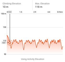
My run starts with downhill part, but it's counted as10m "Climbing Elevation" as can be seen on screenshot:

Why don't you simply zoom the first descent section - you will see instantly whether it is the case or not. There can be easily dents even during a descent - either when you use a barometric altimeter, then due to wind gusts, or due to irregular elevation data in the topographic mode, at GPS-based elevation. Depends also on the device you use - some are more prone to similar effects than others.
Thank you trux for explanations. I've learn a lot from your answers in Garmin forums.
Zooming in Explore shows a lot of dents in descent section. Wind gusts can explain this.
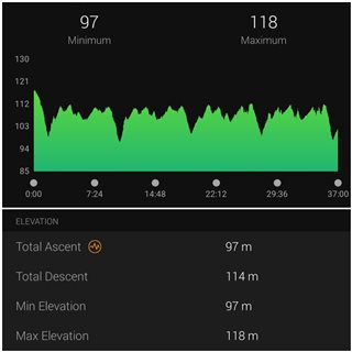
So one more question remain - why is so much difference in stats shown in Explore Map/Activity mode and GCM?
Explore shows total climbing elevation 241m/109m in activity/map mode. And in GCM stats are as in next screenshot

Used device is Fenix 7 Sapphire Solar in auto select satellite mode.
Go to the activity in Garmin Connect Web, and enable Elevation Correction on the screen of the concerned activity. Then compare it with the data from Explore again. If it matches better, it means Explore uses the topographic elevation profile instead of the barometric data.
There was a recent thread about the difference between data in connect and explore: forums.garmin.com/.../why-garmin-connect-and-explore-doesn-t-have-the-same-data