This discussion has been locked.
You can no longer post new replies to this discussion. If you have a question you can start a new discussion

New Create Course feature!

Looks like Garmin has finally added the ability to create a routed course in Garmin Explore, and it actually works pretty well, although the process is a little clunky.

The What's New list from the latest version has :

  • Create courses for your next outdoor adventure by snapping to trails and roads

  • Sync courses to and from compatible Garmin devices

  • Replaced OSM with Garmin's TopoActive maps

I used the Create Course feature today, in conjunction with a Fenix 5 Plus, and it worked great. Previously you could select a point and have Explore start navigation to that point on your watch, but now you can create a whole course, send it to the watch, and start navigation - all from the phone. The catch is that doing that is a multi-step process (create the course, add it to a collection that's being synced, sync the device, then start navigation) - but I tried it a few times and it worked perfectly every time!

This is a huge step forward for both Explore and any devices (especially watches) it works with.  The inability to create a course when offline has always been a big hole in the Garmin ecosystem - but now that hole is plugged!  It also shows that Garmin does seem to be at least somewhat interested in continuing the development of Explore.

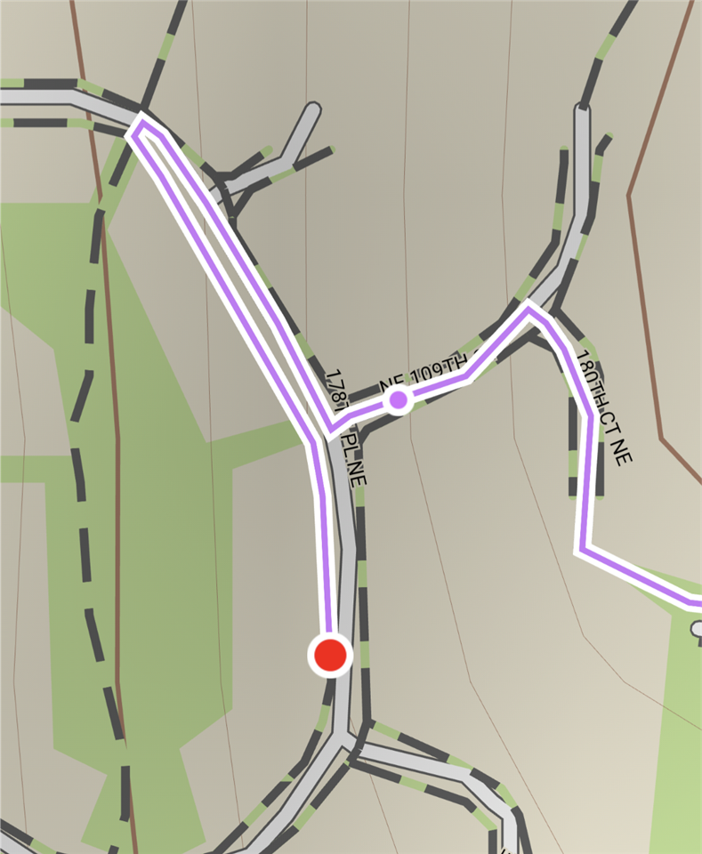
  • I have just tried creating a course using Garmin Explore and think it needs more work. The main issue is that it cannot cross a neighborhood street. It seems to have all the sidewalks separate from streets, and when I try to e. g. make a turn into a side street, it can't just cross a street and go where I need. Instead it makes an arbitrarily long out-and-back to a nearest intersection where it can cross a street, then returns back on another side of the street, and finally goes where I need. Considering that I am talking about narrow neighborhood streets with no traffic, that is simply ridiculous. I assume it would probably work better for a course that is 100% on trails, but every single other course editor that I tried before handles the situation described above correctly.

  • Just tried it on a few streets around here and couldn't reproduce it - but I'm guessing it comes down to the exact maps so that's not surprising.

    Looks like you can handle it manually by clicking on the 'magnet' icon at the bottom, which will stop it from locking to roads. Then draw the crossing and it'll just straight-line it, then turn magnet back on if you want to re-enable routing for the next leg.

  • In my case it explicitly shows sidewalks as separate trails. It doesn't show sidewalks on all streets though - I guess that depends on the underlying map data. Some streets show sidewalks and some don't. In those cases when sidewalks are present, routing is completely messed up as Explore treats those as separate paths and can't jump from a sidewalk to a street. 

    I should add that Garmin Connect mobile (on Android) has exactly the same issue. It doesn't show sidewalks but routes in the same ridiculous way. 

    Here is an example:

  • Thank you for sharing your observations. May I ask on which firmware your watch is on? Because with my Fenix 6X, Explore keeps telling me that i need to update the firmware in order to sync courses. I am on the latest stable release, which is version 19.20. 

    With the synced courses, is the watch also showing navigation hints, like on courses from Garmin Connect?

    It's great that Garmin finally added this feature. What it is definitely still missing is routing options, e.g. avoid roads, avoid elevation etc. 

    Somewhere it was written in the App, that it will take the shortest route on ways where pedestrians are allowed. That may be the explanation for weird routing described by 'silentvoyager'.

  • What is also quite annoying is that the Topoactive maps in Explore are not up to date. They are at least more than one year old, while the maps on the watch are some months old. I can tell because i do some OSM mapping and can see none of my edits from last year on the Explore map. 

  • Pedestrians are definitely allowed everywhere. These are typical small neighborhood streets. There are no crosswalks and hardly any traffic, and people cross them at will. If you look at the example I linked above, it goes to a nearby trail crossing a street, but let me assure you that that crossing is no different than crossing a street in any other place.

    Perhaps I am being picky, but I played with editing a course for 5 minutes in my general area and it seems completely unusable to me. I haven't tried syncing a course to my watch yet.

    Also I'd guess it's that rollout of this feature is aligned with the upcoming release of Fenix 7. That's probably why it doesn't yet work with the current official version of Fenix 6 firmware. 

  • I only saw your screenshot after i sent my reply. Strange that the sidewalks are mapped as individual paths. I think this is not standard. So i also agree on your conclusion, that it is caused by the underlying map material. As a workaround, have you tried to start your course on the street instead of the sidewalks? Then it should route you along the street i guess.

  • Yes, starting on a street works. But that requires a great precision tapping on the map, which might be impossible when the map is zoomed out. In fact, in my example it was on a street, but then I tapped on a sidewalk.

    Anyway, most of the time I create courses that are nearly 100% on trails so perhaps this shouldn't be a huge issue.

  • I played a bit more with the course editing. One really important feature that is missing is that there is no elevation profile available and no information whatsoever about total ascent and descent along the course. That is super important when editing a course.

    Also, it would be nice to have some extra functions like closing a loop (returning back to the start), inserting course points, etc. It tells me how many points on the course when editing, but I'd assume those aren't course points, are they? Example of course points would be aid stations or checkpoints during a race, sources of water, special points of interest, etc.

  • It's an interesting issue.  The problem is that the maps are too good!  OSM for that area has the sidewalks added, and TopoActive is obviously setup to treat those as "trails" - thus you end up with 3 basically parallel paths that only connect at certain locations.

    Around where I live OSM also has sidewalks for some streets, but Topoactive doesn't have them.  I'm not sure if that's because they were added recently and Topoactive hasnt picked them up, or if they have created the maps differently.

    Like you, the only place I'm likely to use this is on trails, and there you obviously want to have as many "trails" as possible included, so I'll be interesting to see if they can fix this without impacting trails.  Interestingly Garmin Connect's course creation can also use OSM, and when you use that it doesn't show any of the sidewalks (but does still show trails) so I'm guessing it is possible.