This discussion has been locked.
You can no longer post new replies to this discussion. If you have a question you can start a new discussion

Show all routes on the same map

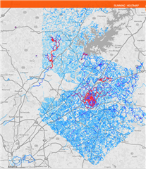
It would be extremely cool if I could view the routes of all my activities (and/or courses) on one single map (not just starting and end points, since they are usually outside my house anyway).

It would be impressive to see everywhere I went with my bike in a certain area.

And it would be fun to plan where to go next by seeing clearly where I haven't been yet.
  • This would be a really nice feature.

    But now we can only do it by hand - using one of other programs.

    Download your activities as GPX files and open in program like those:

    .

    GPX Editor 1.7.14 (File -> Add GPX):
    https://sourceforge.net/projects/gpxeditor/

    Maperitive 2.4.3 (File -> Open Map Sources...):
    http://maperitive.net

    JOSM 15322 (File -> Open...):
    https://josm.openstreetmap.de

    .

    Using JOSM, you can also edit OpenStreetMap and make maps more accurate - adding missing paths. Which can be done easier, as you can see your GPS tracks on the map.

  • All activities can be downloaded using this script.

    Use in web-browser console (shortcut: F12), tested in Firefox.

    .

    Set the limit=200 to match your activities count.

    When downloading larger files, set more wait time: t+=10000.

    .

    Login to Connect website.

    Download 1 GPX file by hand, and click on the checkbox to download all GPX files without asking.

    Now open the console and check "Persist Logs" (to keep logs about all files).

    Paste the script and press Enter.

    jQuery.getJSON(
        'https://connect.garmin.com/modern/proxy/activitylist-service/activities/search/activities?limit=200',
        function(act_list)
        {
            var t=0;
            act_list.forEach(
            function(act)
                {
                    setTimeout(function() {
                        console.dir(act['activityId'], act['activityName'], act['startTimeLocal']);
                        location = 'https://connect.garmin.com/modern/proxy/download-service/export/gpx/activity/' + act['activityId'];
                    }, t+=5000);
                }
            );
        }
    );

  • Me too, but seeing how it's been over 7 years since this was posted, I don't think anyone is listening.

  • Except me, the OP. And I found Strava which had exactly what I asked for (which was basically a heat map). And then I found Veloviewer which made the heat map so much cooler. We're a whole community there, I made this short film:

    www.youtube.com/watch

  • I asked for something like that. I'm a runner. Some of the runs I do I call "coverage runs."  I hope to eventually run every public street in the city twice, eventually covering the entire city.

    I want to be able to choose specific runs to show on a map.

  • Such a  map can be used for "coverage challenges."   A group agrees on an area to be covered, and competes to see who can cover the area first.  Or, it might be interesting to try that without competing to see who can do it first -- just watch the covered area increase by each member of the group.

    A variation is to allow different users to combine their coverage runs onto one map -- a team coverage  map.

  • For that I just use Basecamp on PC or Locus on Android

  • I agree it would be awesome to have inside of Garmin, but until then here is a site that does exactly what you'd like once connected to your Strava account: 

    https://citystrides.com/

  • This is one of the reasons I'm paying for Strava Summit. Also using Google Earth and Basecamp to save every track. Ran every road in my county. Moved to a new county and almost done with that. Saving some of the most dangerous roads for when I can get an escort.