I am part of a growing number of people (Striders) who's goal it is to walk every street in a city.
The website that I am using is called CityStrides. This is my profile: https://citystrides.com/users/14290
I use the CityStrides' "Route Builder" to plan my runs/walks/hikes.
I export the CS GPX file, and upload it to a Garmin Course.
It has been working flawlessly, until yesterday.
Often I will have to walk to the end of a dead-end street (cul-de-sac) and back.
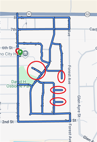
On my walk yesterday, I had four cul-de-sacs. But my Garmin FR965 did not have me turn into the essentially dead-end street.
Under normal circumstances, this might make sense, but under others, ie trying to walk all the streets, it doesn't. It wouldn't make sense for an out and back race/hike either, so maybe there is a distance factor Involved? If that's the case, is there a setting I missed?
Here's what my course looks like, with the cul-de-sacs circled. I can upload the GPX, or you can find the Course here: https://connect.garmin.com/app/course/463928732
Thank you in advance for your insight.
PS. I'll be keeping a closer eye on this, as I have more of Dacono to Stride.