Rectified tracks and elevation

Hi
I rectified my tracks in Garmin Connect to avoid few useless points before and after my activities.
This notably increases the positive (and negative) elevation gain.
For example, I deleted with Garmin Connect the first eight points and the last six points of a trace that has 6685 points.
These points are at these altitude :   
   all at 152m for the first eight points (152,152,152,152,152,152,152,152)
   three at 152m and three at 151m for the last six points (152,152,151,151,151,152)
The track lasted 01h51:25 (6685 points) and the elevation gains was    +531m and -534m.
The rectified track lasts now 01h51:10 (6671 points) and the gains are +571m and +570m.
The difference in elevation gain for these few points at almost the same altitude is 40 meters !
It's the same for all other tracks I rectified in Garmin Connect. Could you explain why ?
In addition, we can't export the rectified track with Garmin Connect, the site always offers the initial track (not rectified). 
Could this be considered ?
Kind regards

  • What exactly do you mean by "I rectified my tracks"? Are you speaking about planned Courses or about recorded Activities? How did you "rectify" them? Did you edit the Course in Garmin Connect, or with an external tool, and then reimported to Connect? Or, in the case you meant a track of an activity - did you edit the FIT file of the activity and reimported back, or did you trim the activity, or changed the Elevation Data Source, or what exactly you did?

  • Hi

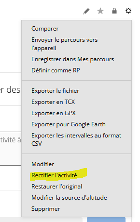
    Yes. I "rectified" the activity with Garmin Connect (edited it if you prefere). it's "Rectifier l'activité" in french in the menu of the activity:


    It's an activity recorded on my FR970 an synchronized in Garmin Connect. I edited it (and other VTT activities) with Garmin Connect. As I said, for this activity in the example, I deleted just few points before (8)  and after (6) with Garmin Connect and registered it. The activity has been modified in Garmin Connect. Therefore, the fit file in Garmin Connect is always the same than before the modification. I don't understand why we can't export the new edited fit file.

    All the VTT activities I edited (with Garmin Connect) have their elevation gains notably increased. 

    https://connect.garmin.com/app/activity/22442193847 is the activity.  I choose it as example because I just deleted 14 points (8 before,6 after) with almost the same altitude (~152m) which would not change the elevation of the activity but did it (40m more, 531m before editing it 571m now).

    KR

  • OK, I see, in the original English version, the function is called "Trim". By trimming an activity, you do not edit the FIT file coming from the device, you only set new starting and ending points that are saved into the database, without modifying the FIT file. They then serve to hide the trimmed parts of the activity, but do not modify the file. Garmin Connect does not generate new FIT files.

    As for why the elevation gain differs quite a lot from the original: the original file contains the elevation gain calculated by the device. For calculating the gain, filtering/smoothing functions are used, eliminating smaller fluctuations (road bumps, vertical body and arm movement, etc.). For the dynamic filtering, the device uses real-time data, with much higher sampling rate than then recorded into the FIT file. This detailed real-time data is not available when trimming the saved activity, so the elevation gain is calculated only with the available elevation points, with a simplified filtering.

    If you want more consistent results before and after the trimming, you could change the Elevation Source to the DEM option (topographical data). While a minimal trimming of a few points without any elevation change can indeed significantly increase the newly calculated elevation gain, with the DEM Elevation Source option, it won't change much. I also noticed that if, after the trim, you change the source back to the Device option, this time a more aggressive filtering is used, and the recalculated elevation gain is significantly smaller. However, in most cases, neither of them will meet your expectations, because Garmin Connect simply does not have the real-time data to mimic the exact same filtering as the device did.