This discussion has been locked.
You can no longer post new replies to this discussion. If you have a question you can start a new discussion

Garmin, please fix the activity elevation graph scaling in PC Garmin Connect

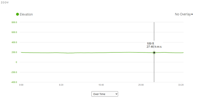
Garmin, please fix the activity elevation graph scaling in PC Garmin Connect.  When viewing the elevation graph in Garmin Connect on a PC, the elevation scaling is fixed at a level which is much too coarse to see elevation changes on the graph in the vast majority of situations.  In other words, the graph is useless visually because of the scaling, which cannot be changed.  Please add an auto-scale feature and/or a manual scaling feature.  The existing zoom feature is of no use regarding this.  Evidently, this issue has existed for many years, but nothing has been done to fix it..


  • We always work to update, and develop our products and apps to meet users needs. Use the following link to pass this suggestion onto our developers: https://www.garmin.com/en-US/forms/ideas/

  • There is automatic scaling on the altitude plots.

    For example on an activity where my minimum elevation was around 1600 and max 2500m the y-axis extent is +1500m to +3000m.

    In another example on a recent activity where my minimum elevation was around zero and max around 30 the y-axis scaling was -100m to +100m.

    I think the problem is that the scaling is not helpful at relatively low altitudes which is likely where many people record activities.

    There are very few places where it is possible to get to -20m let alone -100m so changing the negative part of the chart would be immediately helpful.

  • It is weird.  I opened the low altitude activity I mentioned above in Safari with the tab group sidebar and it shows -80 to +80m.  But if I close the sidebar it rescales to -100 to +100m.

    Your plot above is very poorly scaled.  You could try getting some more examples like that and report them to Garmin Product Support and see if you can get them to agree that it is broken and doesn't just need improving.   

    Good luck!

  • This issue has been around for 12+ years now. There are a lot of threads where users complain about it.

    forums.garmin.com/.../adjusting-scale-on-elevation-chart

    A few years ago, I submitted a suggestion to the Garmin developers via www.garmin.com/.../. But I never received a response, nor was the problem fixed.

  • The earliest posts are over 14 years old!  It was even a sticky thread for a while.

    Automatic scaling of charts is very straightforward to implement as the minima and maxima of the data are trivial to determine before the plot is produced.  It is very surprising that this remains a problem.

    Perhaps it is because all the programmers have their units set to statute, don't see the metric version, and can't understand what the issue is.  Or perhaps it is a conspiracy against people that train at low altitudes?

  • As the charts in the thread mentioned above show, the elevation profile is displayed correctly in GC Mobile, but not in GC Web. These charts have been sent to the Garmin devs. I don't understand why they don't recognize this issue as well and use the algorithm for GC Mobile for GC Web too.

  • The Android and iOS apps are completely different to the website.  In an ideal world it would be the same code but that is unlikely. Different teams, different code, different set of programmers, different budgets, different priorities?

  • The Android and iOS apps are completely different to the website.  In an ideal world it would be the same code but that is unlikely. Different teams, different code, different set of programmers, different budgets, different priorities?

    I agree, but I mean the math for scaling a graph should be the same. Scaling is mainly about estimating the extreme values of a curve so that it fills the available space in the graph appropriately.

  • No estimation is needed.  They have the list of values that will be used to plot the chart.  They scan the list to find the max and min of these and then scale appropriately.   Most programming languages tend to have max() and min() functions that take arrays as arguments, and if they don't it is trivial to code.