This discussion has been locked.
You can no longer post new replies to this discussion. If you have a question you can start a new discussion

Open Streetmap gray on highest zoom north of 60°N?

For a while now, when I try to use Open Streetmap and zoom in to the highest zoom level to see the trails in my neighborhood, the whole map turns gray. I played around for a bit and found that it actually still works further south! The border seems to be around 60°00'00.0"N as you can see here:

https://connect.garmin.com/modern/course/259985329
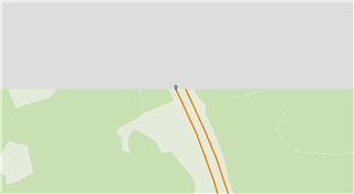

I confirmed with a friend, he is also only seeing gray up where we live. Unfortunately the zoom level below does not show any trails...

Can anyone confirm you are seeing the same? I contacted support when I first discovered this and they told me to report it to Open Streetmap (which I think sounds ridiculous?)

  • I see that as well.

    I some other locations you have to zoom out two steps (for example in Reykjavik).

    Garmin Support should handle that themselfs since everyone is likely affected. We as normal users have no idea how Garmin is fetching and loading the maps from OSM.

  • Yes, you are right! And over in North America, the border is further south, around 45°N.

    In the web browser's developer tools, I can see that there are errors when the browser tries to get the map tiles from Garmin's servers. I included this in my report to Garmin but still got this really strange response from support (translated from Swedish):

    "Hello Albert!

    I have now received feedback from our technicians in the USA regarding the issue you have with us.

    Our technicians have now reproduced the problem themselves and have discovered that it only exists in OpenStreetMap, and not when using other maps in Connect.

    Since we do not own Google [sic] StreetMap ourselves, you will need to manually report this to [Google StreetMap].

    Here's how to do it:

    1: Go to the website OpenStreetMap.org.

    2: Create a free account on the website.

    3: Follow the steps on the website to report map problems.

    After you have done this, OpenStreetMap will handle your case regarding the map discrepancy."

    Maybe I should just try contacting them again..

    Edit: here is an example of a 404 error when trying to zoom in, it's clearly trying to access an image that does not exist on Garmin's servers.

  • When I look in OSM I can zoom in to the 10 or 20 meter level everywhere in the world. Even down to 5 meter level at some places so there is no issue with OSM.

    So, what to report to OSM? Your maps show a resolution down to 5-20 meters level, but Garmin's implementation will stop showing the map tiles when I get below the 100 meters level. They still said that I should report it to you since it must be your fault...

    How is Garmin fetching the map tiles? They are using Leaflet. When I check the examples at https://leafletjs.com/ I can zoom down all the way and all tiles are showing. The details are also a lot higher in those maps than in Garmin's. Exactly what Garmin is doing to not show the higher resolution and to not show the map tiles is unknown. I doubt OSM can answer that.

  • Exactly! I tried to argue the same with them but did not get anywhere..

    I have contacted support again now, this time I selected US as region, hopefully that way I can reach someone more technical directly..