This discussion has been locked.
You can no longer post new replies to this discussion. If you have a question you can start a new discussion

Satellite map view

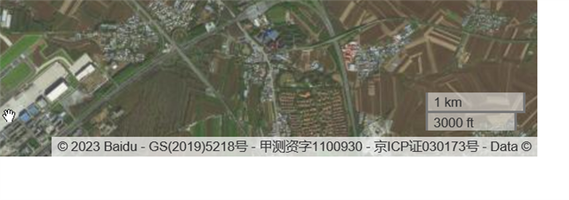
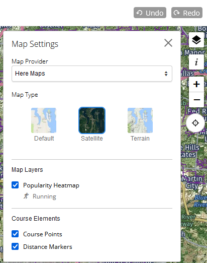
For creating new courses, especially MTB or Gravel, it was super helpful to have the Satellite Map layer available, because you're not riding all the times on roads / ways which are shown in the normal map. Since the new UI is in place, this feature for creating courses is not working anymore. In other views for activities you did, the satellite layer is available, so in general the function is there but it's not working for new courses.
On top of that, (i'm living in China and using an Asia 530, the map is everytim starting in Bejing, i know the party will be happy about this, but that's not necessary.

  • Well, here in the USA, it always starts in Olaithe, Kansas, Garmin's HQ. Hasen't always been that way until a few months ago....

  • Aerial view depends on a map, for Google Maps it's available also for creating courses. So check if you can switch to other map, if you selected one which normally comes with aerial view, then they missed to add that option and you can report them about it.

    For default location, it's very old problem, but earlier it appeared when you didn't have any courses, it was enough to create a course and it moved to location of your saved course, currently it always moves to default location, so it's more problematic.

  • For default location, it's very old problem, but earlier it appeared when you didn't have any courses, it was enough to create a course and it moved to location of your saved course, currently it always moves to default location, so it's more problematic.

    I'd tell it still works, at least it seems to work for me, showing me always the current location even when I am travelling. Though I already have a course in each of the locations I recently travelled to, so that may be the difference to other users who may not see this behavior.

  • Thanks a lot for the feedback.
    Helpful would be now how to change the map.
    I can see two different versions, that right, for the tracks i did already and which are recorded with the Garmin 530 its the following map:

    For the courses the Web-App would like to use the following one where the Sat-Layer is not working

    If i click on this leaflet link, i stop here

    https://leafletjs.com/index.html
    Thats a Software-Developer in Ukraine, i've no idea why they use something like that in China :-)

    Thanks in advance for any help.

    Regards

    Reiner

  • Now it's getting even worse, in the Activities is now no map at all left. Only a grey box. I hope that there are some real developers behind which will solve such problems. Otherwise the product has nearly no value anymore. The iOS App is nice but no way to use that to put some tracks together. Will be time then to look for something else.

  • I'd tell it still works, at least it seems to work for me, showing me always the current location even when I am travelling. Though I already have a course in each of the locations I recently travelled to, so that may be the difference to other users who may not see this behavior.

    It's different now, currently you need to share your location through a web-browser's settings for it to work.

    Earlier it moved to a part of a map where your saved courses were.

    It may seem to be a better option - but it isn't. After allowing Connect Web to read your location - it approximates by IP, and you may get a wrong region anyway. It will be closer to your location, but you may still need to use search.

    Other websites just remember what part of a map was displayed, and it's better.


    Helpful would be now how to change the map.

    It should be at the up-right corner - after clicking on that square layers icon.

    If a map has few options, then those are listed as Map Type.