So I'm trying to do some pretty basic things, but can't seem to get everything to work correctly. Any/all suggestions are greatly appreciated. Here's what's going on...
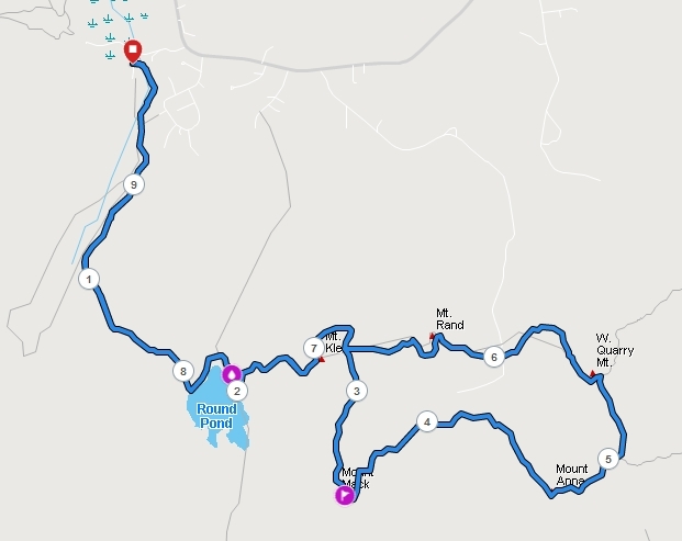
I do a decent amount of hiking and the routes vary between out-and-backs, loops, and what I call lollipops (where there is a common segment combined with a loop - see attached image). I create my maps in AllTrails or CalTopo mostly because they contain many trails that neither Explore nor Connect have. I can export GPX files from both platforms and FIT files from AllTrails.
1. Explore does not let me import FIT files, so I would need to use the GPX format. But half the time, Explore just won't sync with my watch and I've given up fighting with why it just doesn't do what it's supposed to. So...
2. It was suggested that I bring GPX files into Connect, add waypoints there, then export the course as a FIT and drag it into the NewFiles folder of the watch. That does seem to work, however...
3. In the example shown below, I have waypoints at Round Pond and Mound Mack. Loading the course in my watch shows that the next waypoint is Mount Mack (at a distance of about 3.5 miles from the start). Round Pond is viewed as being at 7.75 miles from the start instead of the intended 1.95 miles as it is on the out-and-back section and Garmin is just choosing one direction or the other without any way to set this. I would even be fine if it indicated that waypoint in BOTH directions, but it certainly needs to show it on the way out.
4. Of lesser importance is that I cannot save waypoints to collections like I can in Explore. So if I hike many different trails to these same summits, I need to recreate the waypoints for each different course.
I'm wide open to suggestions for a workflow where I can: Create a custom course, add waypoints that reflect a real-world hike, save the course and waypoints into collections, easily and successfully download desired data to my watch (with or without the NewFiles option).
Thanks very much,
John