This discussion has been locked.
You can no longer post new replies to this discussion. If you have a question you can start a new discussion

Importing gpx tracks reduced number of points

Hi

I have searched the forum but was unsuccessful.

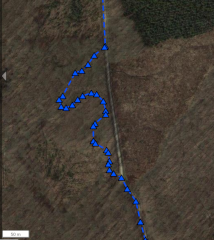
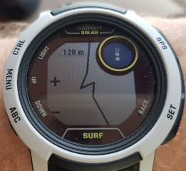
I have a gpx track with 6000 points. I looks that some points have been deleted, so I exported the track and only 1532 were available. This is concerning on crossroads, especially on country paths when the track is sent to the gps device. 

I there any way to import all points into GC?  So all finally go to the edge gps

Any help will be appreciated

Luisja

  • I looks that some points have been deleted, so I exported the track and only 1532 were available.

    That's actually a surprisingly high number. According to the specification, there is a limit of 200 course points:

    Maximum Number of Course Points Supported by an Edge | Garmin Customer Support

    You can try creating your course with a service not having the limitation, and being able to export the course in Garmin's native FIT file format, and then uploading the file directly on the device. For example plotaroute.com can do that. However, your Edge will very likely remove any excess course points anyway. At least my watch does so, when I upload a course with more points than it can handle.

    Other than that, I can only recommend either using a lower number of course points, or splitting the course into several parts (you can load a new course without stopping the activity)

  • Tx trux for your prompt reply, I'll have a look and come back to you in a few days

  • Hi, I'm encountering a similar issue with the Garmin Instinct 2 watch.
    The official documentation mentions a maximum of 50 points for courses.
    However, the watch is obviously capable of much more.
    (50 points is an impossibly low amount of points anyway for tracks.)
    I'm talking about tracks here, not routes. For routes, you can do a lot with 50 points, but for tracks it's a ridiculous low limitation.
    Anyway, my watch can manage much more than 50 track points,
    BUT it removes some of them. Probably some optimization.
    A couple of hundred pretty crucial points disappear from a source track with about 1064 points.
    Unfortunately, I cannot rely on the Garmin navigation functionality if I cannot be certain that it will follow my carefully prepared courses.
    I's also frustrating that I cannot find anyone capable of explaining how the Garmin products really works.
    Even the Garmin support center they seem incapable of even understanding what the issue is.
    Additionally, I don't know if there are any Garmin products out there that would perform better.
    Because the documentation is obviously not correct.
    Did you discover more about this ?

  • I'm talking about tracks here, not routes. For routes, you can do a lot with 50 points,

    Not sure what you call tracks and routes. In the terminology of Garmin Connect, you use Courses (also sometimes called Routes) for the navigation, and the terms "track" is being used for the recorded path of an activity. The difference is explained for example here: Differences Between Routes and Tracks | Garmin Customer Support

    The limit of 50 course points concerns only Courses, and as you mentioned yourself, you can do pretty much with it. Usually you do not need more than that, and if really needed, you can split the course into several parts.

    The limit of track points is much higher, and also depends on the device - for example at Instinct (and many other models) there is no limit in the number of track points saved to the activity file. The only limitation is the available storage space (see the info here: File Limitations of the Instinct Series | Garmin Customer Support). However, different apps may limit the number of displayed points. For example Garmin Explore has the limit of 10,000 track points. The Garmin Connect phone app optimizes the number of displayed track points much stronger, and as well GC web does it (although in a less agressive manner). All that is done in order to speed up the parsing of the map, and limit the CPU/memory use. You do not really need the track points for the navigation. The original FIT file of the activity contains all the track points saved in it.

    If you mean non-navigable track points of a Course, then Garmin indeed optimizes the number of those points upon the GPX file import. If you want to keep the trackpoints like they were designed in the original, I recommend avoiding the import in Garmin Connect entirely. For example at plotaroute.ocm, you can export Courses in Garmin's native FIT file format, and you can then place the file directly on the watch (bypassing so Garmin Connect). 

  • Thanks for your extensive reply.
    Great suggestion to consider a tool like plotaroute to make a FIT file without any optimization.
    Not sure though why you would think that I’m misinterpreting what routes, tracks and courses are.

    Maybe I can make the story less confusing by describing how to reproduce the issue:
    I downloaded a GPX file containing a track (not a route).
    That track was the recorded path of an activity someone else did.
    (I want to do a mountain bike trip, following that exact path.)
    I used a text editor to count how many times the file contains “</trkpt>”.
    The track contains 1064 trkpts (track points).

    Then, on the Garmin Connect website, I import that GPX file containing the track.
    From then on, Garmin calls it a “course”.

    Then I sync the course to my watch.
    Meanwhile, Garmin Connect converts the GPX file to a FIT file.
    At the same time, the Garmin algorithm does a great job optimizing the content of the course.
    After syncing, the FIT file that was transferred to my watch contains only 1042 track points.  
    (I know this because I transferred that FIT file back to my laptop, using USB. Then I converted it back to GPX format and counted the track points again.)

    Here’s a detail of a map generated using the FIT file that I transferred back from my watch to my laptop using USB. So this is actually what I want to navigate:


    So at this point, I’m certain that my watch contains the course that I want to ride.
    Great!

    But here comes the issue:
    When I push the button to start navigating the course, my Instinct 2 watch first does some “loading”. 
    It only does this the first time navigating a course.
    My watch can display the entire course path as a black line on a white background.
    When zooming in on the watch, I can see that a lot of detail has disappeared.
    So the watch does some simplification of the course.

    The Instinct 2 watch reduces the same area into this:


    Unfortunately, this does not allow me to follow the path without making many many mistakes.
    At first, I feared that the watch would reduce the number of points to 50.
    Because the documentation mentions that there’s a maximum of 50 course points.
    But that is not the case. The 50 point course limit must be for routes only I guess, which is fine.
    There are many more points visible here when you zoom/pan on the watch.
    I’m estimating about 500. I ‘m unable to say exactly how many, because I don’t know how to access that data on the watch.
    Anyway, the watch alters the course so that it contains much less points than the FIT file present on the watch.

    I tried navigating that course, and also while mountain biking it was clear that a lot of information had gone missing. 
    So it’s not just the watch map displaying a simplified course. 
    The navigation instructions are missing the same information that has been removed on the watch map display.

    I hope that I have now provided enough detail about the issue. :-)
    I’m afraid that this is an undocumented limitation of the Garmin Instinct 2 watch.
    Really curious if anyone else has noticed this behavior.
    And I hope that there is some workaround, making the watch more reliable.

  • I recommend setting waypoints on the critical places of the course, while respecting the limit of 50 points. If not possible, split te course into several parts, and load them each after other during the same activity (yes, you can do that).

  • split te course into several parts, and load them each after other during the same activity

    Yes I know you can do that. But that is not practical at all.

    My course is not that big, only 40km. And most of the 1042 points on it are critical.
    ( Again, for the people who jumped in, I'm talking about courses based on tracks here, not routes. )
    I really cannot remove many more waypoints.
    Splitting my course into parts of 50 points would result in 21 separate courses! 
    Every 2 km I would have to start another course! That's ridiculous.

    Besides, the most powerful Garmin GPS devices typically have course limits of max 200 points.
    Following your suggestion, that would mean that they allow to navigate a course of about 8 km max.
    This really makes no sense at all.
    We all know that those devices can navigate you along a course consisting of thousands of waypoints.

    So I cannot accept your recommendation as the best possible approach.

  • Frankly told, I do not quite believe you need over 1000 track points, but if it is really so, and you cannot use any of the suggested solutions, then I am afraid you need a different device than Garmin Instinct 2. It is an entry level model, with the focus on battery life, hence with an underclocked CPU, and a very small internal memory, in the sake of saving some power, hence processing huge navigation files is a challenge.

  • :-)
    I would love to hear a Garmin expert about this.

  • I would love to hear a Garmin expert about this.

    Not a big chance any Garmin expert would post here. Call the Support, and if not getting the answer from the first level support, ask them to pass you to their supervisor.