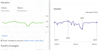
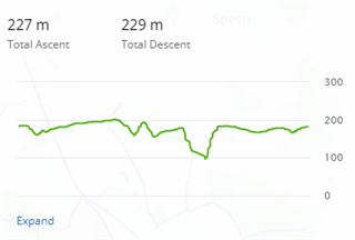
I'm having issues with plotting routes in Garmin Connect on a desktop. It is massively undercooking the elevation gains on trail runs meaning that the PacePro strategy I then sync to my Forerunner 945 is wildly off (and quite demoralising!).
In the below screenshot, the left elevation map is from Garmin Connect and the right hand one from OS Maps (I'm UK based). You can see the hills in the middle which Garmin Connect completely neglects. This isn't a barometric vs GPS issue like previous posts - it is just flat out poor contouring on the Garmin online map before I even get out running!
What map and what resolution contours are the elevations based off for course maps?