
I went on a hike towards Etna on Friday. I stopped at Monte Josemaria Escriva and Garmin's GPS tracking, after corrections have been enabled, is precisely showing the position:
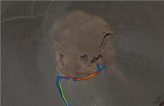
I understand that sometimes the GPS tracking can be off a little bit but in this case it's much more. Reported height of that crater on the ridge where I was standing is around 2672m
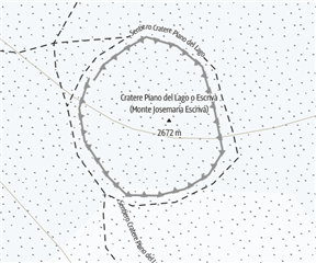
(OpenStreetMap)
But my max elevation reported by Garmin is 2587m - that is 85m off.
Disabling the corrections doesn't change the maximum elevation, only the total descent (2125m - enabled, 2658m - disabled) which is also a big difference.
I can't explain it. Any thoughts?