This discussion has been locked.
You can no longer post new replies to this discussion. If you have a question you can start a new discussion

Connect showing no heatmap data for popular mountain bike routes

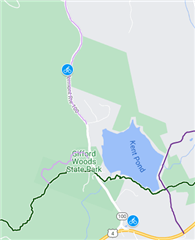
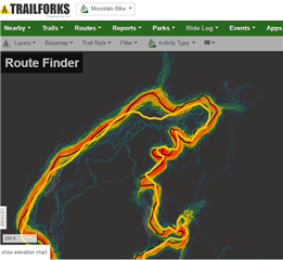
I'm finding that for some popular mountain biking areas Garmin has zero heatmap data. Where other services like Strava and TrailForks will clearly show that very popular routes exist, Garmin's heatmap is completely blank. This makes Connect useless when it comes to creating a mountain biking route for that area. 

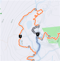
For Example: the Sherburne Trails trail system just north of Killington, VT is very popular as reflected on both Strava and TrailForks but according to Garmin these trails don't exist and/or never get ridden. See attached screenshots. 
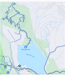
Would appreciate an explanation from @Garmin Support!

  • The heatmap bases on OSM paths/roads. But it's updated very rarely. They have the cache server.

    The path, Pond View, above Kent Pond was added 2 months ago on OSM - you can right click on it and search for objects at that place, then select it and choose history.

    Adding a path is the first step, then you need to wait a year or so until the heatmap's paths update occurs. But you may get lucky if a path was added just before update, then it may be faster.

    Yup, updates are way too slow.

  • Thanks for that @BunBun! 

    If Garmin can't help what is the best way to create a Course I can follow on a Garmin device for an area like this? 

  • Create GPX on other site and import as course, or make one from already recorded activity.

    Or use existing courses, there seem to be one for that path: https://connect.garmin.com/modern/course/76052442

  • Good points @BunBun!. Thanks for your input. 

    However, as I continue to explore this issue I find there are issues with each approach I try. I'm going to use this thread to try to document my observations in the hopes it will help others at some point...

    So, starting with following someone else's track... The problem with this approach is that, as has been well documented, GPS devices have trouble following exactly the routes we take. Tight, twisty single track in heavily wooded areas exacerbates this issue. 

    This screen shot from Trailforks shows the Heatmap for a popular riding area in Connecticut (Crescent Lake). The Orange highlight is the heatmap. The Yellow line is a track created by a Trailforks user. As you can see there's quite a discrepancy. Enough so that if you were to follow this users' track your device would likely be switching between "Off Course" and "On Course" indicators throughout the ride.  

    It seems that the best way to create a Course to follow would be to use a tool that allows you to easily trace the mid-point of the heatmap. Thus far I don't see a way to do this with either Trailforks or Strava.  And obviously not Garmin given the original topic of this thread. If anyone knows a way to do this please share. 

  • Update!

    It appears that Strava will in fact let you create a Course by "tracing" the heat map for a giving riding area. But there's a few tricks and exceptions.

    The first thing you need to do is make sure you set the map up with the following preferences: "Mountain Bike", "Follow most popular", "Any elevation" and "Prefer dirt surfaces". That last one seems to be critical. 

    However, even if you do this Strava will still "fight" with you at certain times if there is a road nearby, another trail nearby or a marked trail on the map that differs from the heatmap. In these cases you'll have to switch to Manual mode and make a bunch of little points to follow the heatmap then turn Manual mode back off. 

    Overall the process for a roughly 10 mile ride can become quite tedious. 

    Also, the heatmap gives no indication if a given trail is intended to be ridden in one direction versus the other. In some instances you can reference Trailforks for help determining which is the preferred direction, but not always. 

    So, not ideal but it can be done.  Also, I believe this feature will only be available to paid subscribers of Strava. 

  • GPS devices have trouble following exactly the routes we take. Tight, twisty single track in heavily wooded areas exacerbates this issue.

    That's true. When I add missing paths to OSM, I use my recorded tracks by GPS, photo-map and relief-map. This way you can create very accurate path, though, it depends on quality of available photo and relief at a given area.

    Some mappers also add layer with heatmap from Strava as additional check.

    It can be done in some editor like JOSM.

    And when a path is added to OSM, then after longer time it will be available on Connect, when they make a new copy of it. Some other sites which use OSM's data update more often. Though, you can be sure if some path is accurate if you compare or add it yourself, some may be only approximation.