This discussion has been locked.
You can no longer post new replies to this discussion. If you have a question you can start a new discussion

Garmin Connect cutting edges in activity map

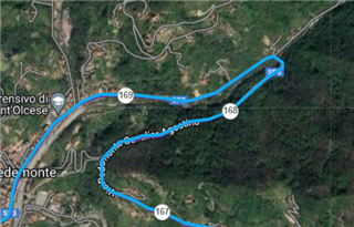
Hi evryone, this is my activity as displayed from Garmin Connect WEB:

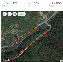
Same activity from Garmin Connect APP:

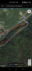
And the same activity viewed from TrainingPeaks:

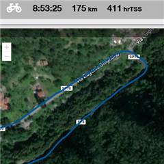
I think that my Fenix 7 had recorded the activity well, one second sampling, and it's very precise in TrainingPeaks, but for some reasons all Garmin apps seem to "cut" points while drawing the maps.

  • Could you share a link to the activity?

  • It seems to log very few points. Which type of tracking are you using? To make sure you get the most accurate tracking you should set it to log every second. 

  • No, this is impossible: as I told you, my recording configuration is 1 second and  the same activity is displayed correctly by TrainingPeak, so the GPS points are present in the .fit file.

  • Sure

    <iframe src='connect.garmin.com/.../8953106688' title='Girello al lago di Giacopiane' width='465' height='500' frameborder='0'></iframe>

  • OK, it looks good, the data is there. If you save the activity as Course, many more points are included. See it at https://connect.garmin.com/modern/course/109148003 - that's your activity saved as course, and the concerned curve contains also the points missing in the activity map.

     The reason why the activity shows only reduced number of points, is for the sake of data transfer speed and its volume. The map points alone are not a problem (that's why the course contains more of them), but each dat point in the activity file includes up to several dozens of additional data fields (HR, speed, power, altitude, respiratory rate, duration, cadence, speed, grade adjustment speed, stamina, etc., etc,...), hence it would take quite long time, and a huge volume of data, to download such a long trip.

    Garmin Connect therefore limits the maximum of points, to speed up the download. In the case of GC Web at this activity, the number of points is limited to 1881, instead of the 3300 waypoints shown in the course. The course contains only the coordinates, hence the number of waypoints do not need to be limited so aggressively.

  • You could also try the following test: trim the activity to a shorter section around the concerned curve, lets say just something around 10km long. Save it, and check whether it shows a more detailed track when trimmed. Do not be afraid - you will not lose the trimmed off data - the trimming is reversible any time, even after saving the trimmed version. Just click "Restore Original", once you checked the trimmed version.

    Training Peaks apparently also does not filter any points (or not as many), but I do not use TP, and hence have no access to their data, so cannot tell whether the map data includes anything else that the coordinates or not.

  • BTW, if you use the Every Second Recording mode, then with the 7hr 45min of moving time at this activity, the total number of map points should be around 27 thousands, so it looks like even the course is filtering them, just less aggressively than the activity map. I would need to see the FIT file of the activity, to tell for sure, whether it contains all those 27k points, or not,