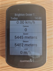
Just made a course in Garmin Connect with 852/890m elevation gain/loss. Once I upload that to my Garmin Edge 530 it becomes 5445/5482m ascent/descent, making any climb features or 'elevation remaining' data fields useless. The elevation graph looks roughly ok, suggesting the overestimation might be coming from the wiggle on entire length of the route.
Just to clarify, I believe the 852/890 numbers are roughly correct and 5000+ are way off. Here's the link in case it helps https://connect.garmin.com/modern/course/62502503
Any hints how I could fix that?