This discussion has been locked.
You can no longer post new replies to this discussion. If you have a question you can start a new discussion

Elevation issues during course export/sync

Hi, since last week, I have been experiencing problems exporting courses from web or mobile Connect to Garmin Edge 830. Ascent/Descent meters are two to three times bigger than reality – than in the route prepared or imported into Garmin Connect.

I found that the cause is in the FIT file. When I download the file from Garmin Connect and analyze it using for example https://www.fitfileviewer.com, I see that the incorrect altitude values are already in this file.

When I load this FIT into Edge, the route elevation data shown is incorrect. When I use GPX, everything is fine. But Garmin uses the FIT when synchronizing.

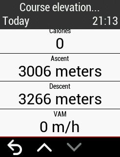
You can try it yourself with this shared route: https://connect.garmin.com/modern/course/58498287. The elevation gain shown in Garmin Connect is 1134 m. After sync with Edge I see Ascent 3006 m (or after FIT download and analyzing).

This behavior began around May 6. Can anything be done about it?

  • I'm having a similar, possibly related issue. On May 6th, I bought a new Garmin: The Instinct Solar watch - which supports Courses and has a barometric altimeter. (My previous watch was a Forerunner 35 - which has neither).

    So, I began using the Garmin Connect Course designer on the web. For a given Course I design on the web, after I sync it to the watch and record it, the altitude recorded is approximately 35-80% higher. I exported the Course to a GPX and imported it into the AllTrails app. Similarly, the altitude recorded on the Alltrails app on a phone is maybe 25% higher than the Course web designer. This seems to be a consistent thing - and I'm tired of it.

    One example:

    Garmin Connect Course web designer: 894 feet
    Garmin Instinct Recording (watch altimeter readings used - "Elev Corrections" disabled): 1598'
    Garmin Instinct Recording (altimeter ignored - "Elev Corrections" enabled): 1782'
    AllTrails phone app recording (phone has no altimeter): 1355'

    The variation between these numbers is mind-boggling! Which is correct??