This discussion has been locked.
You can no longer post new replies to this discussion. If you have a question you can start a new discussion

Connect Showing Roads That Are Not Roads

Former Member
Former Member

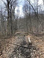
I recently planned a road cycling course and encountered a very unpleasant surprise about 20 miles into the 53-mile route. On the map, Connect showed one segment of the route as a named road, but it ended up being a very rough 6+ mile hiking trail through the woods with no way out. I had to walk my bike through very rocky terrain and muddy conditions for most of the 6 miles. To put it into perspective, the only real way to get through this was on foot or an ATV.

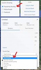
I would like to know how it is possible for this to happen, as Connect allows me to select this segment whether I choose "Popularity Routing" or "Follow Roads". I want to be sure that any road cycling route I plan only includes paved roads, but am not seeing any setting in Connect for that.

I have attached a picture showing the mud and one of many impassable sections of the "road"

Any input on this would be appreciated.

  • I do not think Garmin keeps an own database of bike trails. More likely they use one from Google, HERE, or from OpenStreetMaps - depending on your selection. Try changing the map provider, normally it has an impact also on the road choice. You have to move the starting or ending point slightly, after the change, to have the route recalculated. Also make sure you selected a Road Bike Course Type, if you want just roads (works better with OpenStreeMaps and HERE, than with Google).

    If still not satisfactory, plan your courses with an external tool - there are countless of similar services. One which is popular among Garmin users (since it can export the courses in the Garmin-native FIT file format including turn-by-turn navigation instructions) is at plotaroute.com. Some services allow you to choose routes for MTB or for a road bike (besides plotaroute.com also for example mapy.cz).

    And regarding the popularity map - if the trail is popular and frequetly used by other cyclists, Garmin can barely do anything about it.

    You should perhaps stop overrelying on the technology, and keep some common sense. If you see there are roads crossing woods and fields in your course, it was a rainy weather in the past days, and you do not like riding in the mud, you better choose a different one.

  • Former Member
    0 Former Member over 4 years ago in reply to trux

    Thanks very much for the response. A few points of clarification on my experience...

    1. The road/trail I encountered was not a bike trail and does not appear on the route when I check the "Bike Lanes and Trails" option or the popularity map in Connect
    2. I tried recreating the route using Open Streets and Here and both allowed me to select the bogus road
    3. Your point about over-reliance on technology is valid, but I should mention that I have planned routes like this in the past, many of which go through completely wooded areas (road going through a completely green area on the map). This is the first time I have ever encountered something like this. The map shows the trail like it would any other road on the map, so I had no reason to question it
    4. Here is what it look like on the map:

    In this case, you make a right turn off of Split Rock Rd (paved) onto Charlottsburg Rd. (unpaved) If you follow Charlottsburg to the end, it appears as any other normal road on the map but as I said, it is impassable on a road bike

    I checked this on plotaroute and here is how it displays the road:

    Given Garmin's prominence in the GPS and mapping space, I find it unacceptable that they are not using the best possible technology to ensure accuracy. This is a blatant mapping error, so in my opinion, Garmin needs to evaluate the options they provide on Connect.

  • The road/trail I encountered was not a bike trail and does not appear on the route when I check the "Bike Lanes and Trails" option or the popularity map in Connect

    I see no such option ("Bike Lanes and Trails") in my Garmin Connect. I can select between Popularity Routing, Follow Roads, and Freehand, and then I can chose "Road Cycling", "Mountain Biking", and "Gravel/Unpaved Cycling". Which of the options did you use?

    Could you post the starting and ending point that you used for creating the Course, so that I test it from my side, to see whether I get the same results? Or make your Course public and post the link here.

  • If it helps, I created a public course that follows this route. https://connect.garmin.com/modern/course/46128553

    On Garmin Connect there are no other public cycling courses that follow the same route. They all turn East at about 2 miles in on Charlottesville Rd and none of them are Road Cycling courses. I did notice that the strava heatmap shows this is a fairly active trail, likely all of them are mountain bikers, trail runners, or hikers.

  • Former Member
    0 Former Member over 4 years ago in reply to seilogramp

    Thanks and I would agree with your assessment. Definitely NOT a road bike trail...lol.

  • Former Member
    0 Former Member over 4 years ago in reply to trux

    My apologies, as my statement was not clear. I meant to say that when I select "Bike Lanes and Trails" on the right side of the map, it does not show anything for the segment I have been discussing. When this option is selected, it normally displays dotted or solid green lines in various places on the map, presumably meaning these are frequently used cycling trails. My point in mentioning this is that the segment does not seem to be a common cycling trail, nor does it show up when you select the popularity heatmap option...at least not when you use Garmin's mapping options.  Here is where I select this:

    Here is the link to my complete course: connect.garmin.com/.../43284490

  • I have had the same experience multiple times. How hard is it to show dirt roads vs. paved roads?  Openstreet is better - but it still shows hiking trails as named roads and allows you to plot a 'paved roads only' course right over them.  Total garbage that Garmin has not fixed this.  I've seen this same issue in multiple threads ... also annoying that Garmin does not even reply with an answer or suggestions.  Thanks to all the users here who are trying to help out.