
Did you ever notice that you've got a choice of several base maps when you create a course? Your choices are HERE Maps, Google Maps, and Open Street Maps. I've been using Google Maps as the underlying base map, but I'm going to argue in this post that you should switch over to Open Street Maps. (I don't know anything about HERE Maps.)
Yesterday I ran a course I created in Garmin Connect which used Google Maps as the base map. I was running from north to south on Pine Street in DeLand, Florida. This is what that section of the map looked like:
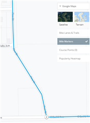
You'll notice it takes a slight leftward jag. Unfortunately, when I reached the corner of Watts and Pine where the slight jag was, this is what I actually saw in front of me.
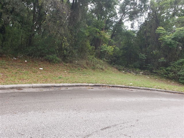
If you look carefully, you'll see a faint trail. I followed the trail, and it brought me to Euclid Avenue where I was able to turn to the east. No harm done.
But when I got back home, I thought I'd look at Open Street Maps and see what it showed.
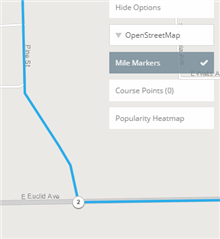
It's a little hard to see, but basically there's no street under that route where the jag is.
The conclusion is that in this case, the Open Street Map is more accurate than the Google map. I'm not going to argue that this is true all the time. I may have found the one case of this being true.
However, I'm going to talk about correcting the base map. Have you ever tried to correct a Google Map? It's difficult, if not impossible You need to submit the change, and it gets reviewed, and it may, eventually, show up. On the other hand, Open Street Maps uses the same editorial policy as Wikipedia. If you want to make a correction to the map, just do it. The map now reflects your updates. So the underlying maps will be updated constantly with better and better information.
I've heard that the maps on Garmin devices are based on Open Street Maps. This means that your corrections will also be shared with your fellow Garmin users whenever Garmin updates their maps. In fact, it's not that difficult to upload the latest maps from Open Street Maps to your device for free rather than waiting for Garmin, which will reflect the very latest corrections from all of the other users. (I suppose if you're really obsessive about it, you could upload maps every day.)
So my recommendation is two fold. First, use the Open Street Maps base map when creating courses on Garmin Connect. And second, when you run across an error on the map, go to Open Street Maps and make a correction so everyone's usage of the maps is improved. It's really not all that hard. I've made several based on my runs and walks in Daytona Beach and Deland. Why not join me.
Fred
(FredrikC on Open Street Maps)