This discussion has been locked.
You can no longer post new replies to this discussion. If you have a question you can start a new discussion

Garmin Connect Courses elevation gain grossly overestimated.

When creating a course on Garmin Connect the elevation gain is grossly overestimated. I can download the GPX and upload to other programs (e.g. strava) and the courses match reality. It is very large over estimate of 30-40% and obviously wrong by inspecting the plot. Anyone else seen this and is there a fix?
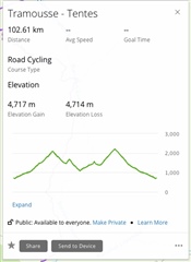
Note same file in Strava is approx 3200m elevation gain.

  • A test route created in GC: elevation gain 303m, elevation loss 359m
    The same test route created in Strava: elevation gain 37m, elevation loss 90m

    This is a different issue than the main issue discussed in this thread, too. In your case, Strava simply uses a different DEM (Digital Elevation Model) than GC, and Strava additionally also applies some smoothing filter on the track, or resamples the track with lesser number of keypoints. The question is now, which of the two is closer to the reaility. They may be both wrong. When you run the same course through the GPS Visualizer tool, modifying the DEM model, you get wild differences in the Elevation Gain, too - i.e. the Elevation Gain of 81m with the NASA SRTM1 DEM and 288m with the NASA SRTM3 DEM.

    Still no answer how to solve it?

    Still the same answer as in my previous suggestion: use Plotaroute for designing the course, if you need to transfer it to your device with better elevation data. And if you just want to see the elevation gain using a different DEM model, or want to fine-tune the vertical and horizontal noise filtering, use the GPS Visualizer tool.

    And if you want that Garmin makes some changes to their DEM or to the filtering algorithm, contact Garmin Support or use the Idea Suggestion form, to let them know, since they will not see your demand here, on the user forum. 

  • Thank you DanielM and trux for suggestions - I sent an e-mail to Garmin support 

  • I have opened a ticket with Garmin a few days ago and they replied to me that they are aware of the problem and they will try to solve it. 

  • In my experience, Strava is always pretty accurate while GC is always way off.

  • In my experience, Strava is always pretty accurate while GC is always way off.

    In this case they seem to be both off. However, the true question is how to measure the elevation gain accurately, and wheter to filter away smaller bumps on the road, or not. BTW, from what do you judge that Strava is pretty accurate? From the barometric altimeter on your Garmin device? That's even less acurate than anything else, and not reliable at all.

  • Yes, I check against my barometric altimeter, which I find pretty accurate. For example, on a road which doesn't have any descent, starts from 120 m and ends at 970 m, the barometric altimeter marks quite accurately always around 850 m, same for Strava, while GC marks around 1200 m. 
    The same happens with my trail running or ski touring activities. Especially in the latter I can easily estimate the true elevation gain directly from the paper maps and the barometric altimeter is always quite accurate (+/- 50 m every 1000 - 1200 m). The only troubles can emerge on a very very windy day: if the watch is exposed to the strong winds, it starts marking a lot of non existent uphills and downhills. Solution: keep it under your jacket as much as you can.

  • on a road which doesn't have any descent, starts from 120 m and ends at 970 m, the barometric altimeter marks quite accurately always around 850 m, same for Strava

    But who tells it is correct? The barmetric altimeter is by principle very inaccurate, due to the pressure sensor hysteresis, its speed (hence ignoring many small altitude changes), due to the atmospheric changes during the ride, and due to the pressure changes and Bernoulli's effect caused by the wind gusts and by the air flow during fast rides. Not speaking about problems with the pressure sensor hole being clugged with water and/or dust.

    So frankly told, taking the values of the barometric altimeter would be the last option I would consider when evaluating the accuracy of the eleveation profile.

  • there is a new test for the edge 130plus bike computer on DCR and you could even with a little calculation see the exact same problem when a strava route is imported for explaining climb pro: www.dcrainmaker.com/.../comment-page-1

  • I am experiencing the same. Route on Connect is listed as 3,800 ft of elevation gain, route on Komoot, Strava, and after recording 2 separate activities with a Fenix 6 and an Ambit2 is ~900 ft. There is of course variance in how the elevation gain/loss is calculated, but one would expect all platforms/devices to settle at a reasonable 10% difference.

    The issue here, I think we can all agree, is that if one would like to use Connect to create a route (say because of the popularity heatmap, which is no longer free in Strava) there is no way to know what kind of ride you are signing up for.

    Thanks for opening up a problem Isabeksu. 

  • opening up an issue*