This discussion has been locked.
You can no longer post new replies to this discussion. If you have a question you can start a new discussion

Garmin Connect Courses elevation gain grossly overestimated.

Former Member
Former Member

When creating a course on Garmin Connect the elevation gain is grossly overestimated. I can download the GPX and upload to other programs (e.g. strava) and the courses match reality. It is very large over estimate of 30-40% and obviously wrong by inspecting the plot. Anyone else seen this and is there a fix?
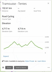
Note same file in Strava is approx 3200m elevation gain.

  • I have the same issue. When I import a .gpx file in Garmin Connect the total ascent is as expected. When I send the file over to my Fenix 6 watch it is nearly 50% more. The only solution that was pointed somewhere in the thread was to manually convert the .gpx file to .fit and then upload it via USB cable. But when I am on the road I don`t usually have a laptop with me so this makes transferring existing routes with correct elevation profile to my watch impossible.

  • That does indeed sound like the same issue. Except the part about everything looking ok in Garmin Connect. Normally, when importing a (or creating a new) gpx file in Garmin Connect is the first place the issue arrives - due to Garmin Connect's flawed elevation calculcation (discussed to great length in this thread), then the issue simply follows to any device thereafter on which you use this route from Garmin Connect.

  • I can just advise another workaround: the Komoot ConnectIQ App. When the course is imported via Komoot (first browser based in their ecosystem, later onto the watch) the elevation is correct. No point by point navigation though…

  • This way I`ll have to use Komoot ConnectIQ App for navigation as well? Because when I do it this way I cannot see the course in Navigation->Courses that is from Garmin.

  • no, if i download the route via the app, so that its saved for offline use, i can and always do access them via: running/ trail running menu, navigation, courses

  • Yep, this might work, but I am not using Komoot. Doesn`t make sense to me to pay another service since I am already using Garmin ecosystem. I contacted support, will see what they will reply. Thanks for the advise.

  • Hi, you may have tried this already, but if you find a known locating that you know the elevation of, you can set the Garmin's elevation while physically being at the known place and then hopefully, the Garmin will report elevations closer to the "truth"?  That's the way I've been going about it.  Good luck!

    Shawna

  • Hi - just wanted to add - this has been very broken behavior for some time - but as others have mentioned I think it recently became slightly less broken.

    For example - if you do the following on the connect.garmin.com website:

    1. find a public course and duplicate it and save it, you will notice the elevation is increased in some random way.  sometimes (often) it nearly doubles it for me. 

    2. then close out of all this and re-enter the course area of your courses where you have the course with the faulty elevation.

    3. now click edit, and then save again, it has now saved it with the correct elevation.

    In reading the rest of the thread, it seems there is lots of opinions on this matter.  Working at a GIS company, I can assure you, the default elevation calculation is broken, hence why in many cases it matches no watch, no other tool, even commercial GIS software that is used for mission critical calculations calculates the elevation much more similar to komoot, strava, and the general GPX/baro data coming off a garmin watch.