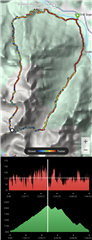
I do hike a lot with my Fenix 6. After the hike I have the recorded GPS track, and other data like HR, elevation, pace etc. I would like to have an overview in which I can interactively pick any position on the recorded hike path, and then get the plot of HR / elevation / pace to automatically show the values recorded at that locaiton. And vice versa: to have a functionality to drag across the plots and get the location marker move correspondingly on the recorded hike path. A bit like what I show in the attached pic (my vision for how roughly it could look like). Is it possible in Garmin Connect? Or do I need some external app for that? What Garmin provides by default (visualization of values of properties like pace with colors on the map) is not sufficient for me.