
Hello everyone.
I asked on chat the Garmin suport about the posibilities to change or show our track in a map that shows details like topo, and they sent me to walk away and try google earth or another services.
The basic idea I wanted to expose is that I would have liked to use the Garmin Connect application together with the map to be able to orient myself in the field in hiking tours, to be able to have details such as contours, nearby peaks.
I walk quite a lot on unmarked roads and so far I have been satisfied with the support and maps I have found using Suunto Ambit3 and their application.
I thought I was upgrading and I bought a Fenix 5x Plus, but I was hit hard by the lack of support as well as the lack of possibilities.
Google Earth doesn't help me and all I have to do is sync the tours recorded with the new Garmin, in the Suunto application so I can see the details in the field that I want.
Until I let the disappointment overwhelm me, I ask you what solutions you have in relation to the problem of maps without details from the official Garmin applications (Connect Android / Web).
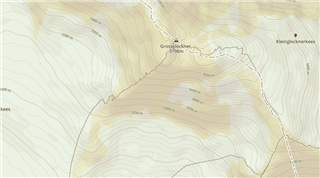
Look at these map (mapbox - Openstreetmaps)
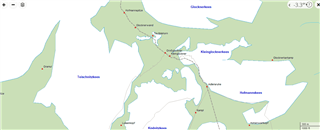
And now look at these (Garmin)
Understood my concern?
I really dont want to believe that Garmin sucks on maps.


