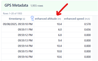
My baro sensor is dead - altitude data can changes from -1000 m to +7000 m in minute. How can i log my activities with GPS altitude data. Can't find apps with this feature in Garmin IQ
Help me!
Thanks
My baro sensor is dead - altitude data can changes from -1000 m to +7000 m in minute. How can i log my activities with GPS altitude data. Can't find apps with this feature in Garmin IQ
Help me!
Thanks
Depends what exactly you are looking for, but the GPS elevation is already available without any IQ app:

Maybe I didn't explain it quite clearly. There is a standard running (walking, cycling) application in the watch, you can set the data field "altitude GPS" and know it, but the application will still write "altitude" to the file according to the barometer (which does not work). I want to find something that will take the "altitude GPS" data and write it to the training file
but the application will still write "altitude" to the file according to the barometer (which does not work). I want to find something that will take the "altitude GPS" data and write it to the training file
That's why I suggested changing the Elevation Source (formerly known as Elevation Correction) - you can do it in Garmin Connect Web regardless whether your barometric altimeter works or not. And you do not need any IQ app for that. The only inconvenience is that you cannot save the choice, and have to switch the source each time you open the activity.
And as for the training file - as I explained, it contains both types of the elevation data - the barometric as well as the GPS based elevation. So if you use the activity file for some further processing, the data is there.
Otherwise, a CIQ app cannot overwrite the native elevation data or the chart. It can only add a new one, which won't be used by the watch for calculating any metrics (or for awarding badges and challenges) anyway.