Basecamp showing incorrect roads

I updated my maps on my Garmin Drivesmart65 with Alexa to the latest version at this time (2025.10) and also installed the same map to the computer both via Garmin Express

Once this was done I went into Basecamp and made sure the latest map was selected ( I later removed all other maps) then proceeded to create a car route.

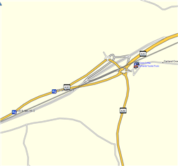
However despite a road being upgraded to a dual carriageway/motorway the map shows the old road in orange and the newer road greyed out.

The road of course looks nothing like this.
Here is the same section in Google maps
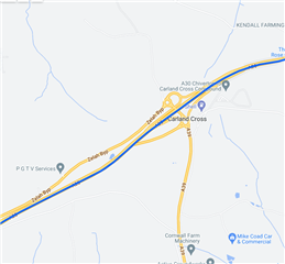
If I try creating a route through this section of the map, the route goes all over the place.

Is this a bad map update, or is there a map I can use in Basecamp which is correct and I can actually do my route properly.

This is just an example but there are other places I have found that are pretty similar.

I will say this is part of a 200 mile route so is pretty key to get things correct on my sat nav.

  • This is a map issue and not a BaseCamp one. You can report map errors to Garmin here

    support.garmin.com/.../

  • I would be tempted to re-install the map.  My thinking is that large companies will be using multiple servers to handle the volume of traffic and that, occasionally, not all of the servers will get updated.  This looks like a map that might be in the process of being updated rather than the final product.  Personally, I have never seen a current/old road along with the new/future route on the same map.

  • Thanks I did look for the reporting, but basecamp one does not work.

    This is more of an anomaly given the road is currently being built and like many roads in the UK, they add carriageways to existing roads and build the accompanying flyovers and roundabouts on each side of the proposed new road. The problem arises when it is put in on a mapping program like basecamp and roads which are not there as yet are taken as being part of the route.

    In the top picture the upper roundabout is being built and is not part of any current road, the lower roundabout is built and the road system goes through that roundabout and straight on. The auto-route tries taking you right at the bottom roundabout to the non-existent second roundabout.

    You could say both Google and Garmin/HERE have this wrong, but I suppose a compromise has been reached in each case. If it were not for Google Street View, I would not have expected that the real route in the end is quite simple. Ignoring any auto-route for that area is the best bet.

  • This is why the routing gets messed up. Let sleeping dogs lie until they bark.

    Better to not have put the road being built on the map at all until it was actually built.

    P.S I did remove all the maps and reinstall, with the same result.

  • Map errors like this are pretty common here in the U.S.  I was once routed off an interstate highway exit that did not exist.  I researched it when I got home and found that it had been removed three years prior yet that map I was using was the most current available.  Last year I was routed by Basecamp along a state highway that was under construction (cleared and graded but no road surface yet).  I assume whatever entity that reports changes to the map folks must have reported with its scheduled completion date regardless of the fact that it was way behind schedule.  I caught that one with Google Maps before the ride.  I had started using Google Maps to confirm my Basecamp routes.  I now often creating them in Google Maps first and then reproduce them in Basecamp.