Enter in an offset to correct the map/plots

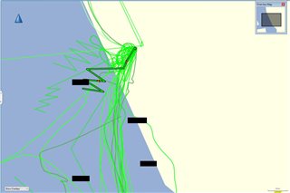
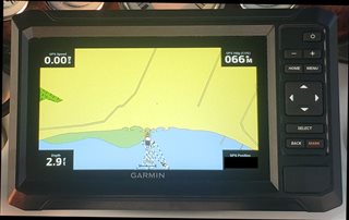
Hello. I am using Basecamp to process data for my Echomap. The plots of our movement are offset by about 1700 feet, as shown in the attached image. Is there some way to enter an offset into basecamp that changes this?

Plus I encountered a very significant change in a sandbar that poses a real threat to someone using the Garmin marine maps, and would like to report that for a map update, but have not figured out how to do that either. The Basemap's 'report an error' selection just ended at a blank popup screen.

Thanks. 

  • Map errors need to be reported on the Garmin website.  Search the internet for:  report garmin "map type" map errors.  Where "map type" refers to something like automotive, outdoor, marine etc.

    I'm not sure what I'm looking at or what you wish to accomplish.  If the recorded data on the device is off by 1700 feet, there is something seriously amiss with your device.  It would not be possible to shift the underlying map.

    The Global Map in Basecamp is not the most accurate.  I'm not familiar with Garmin's Marine devices or map products, but here are my suggestions.  If you can attach you device the computer, it may allow access to the maps on the device.  It will take some time for BaseCamp to index the maps, so be patient.  You could also try a free Open Street Map to see if its shores/banks are more accurate than the Global Map.

    If you are after an image, most devices are capable of taking a screen shot.  Another alternative would be to export the track as a kml and view it in Google Earth.

  • BT, thanks for the response. Attached is a photo of the screen of my Garmin echomap, when our boat is docked. It is very accurate as to depicting where the boat is relative to the dock/shoreline etc.  


    The Basecamp program shows the boat to be about 1700 ft 'ashore' (original post image). When I check the latitude and longitude in Basecamp and on the Garmin for the boat docking point, they differ less than 0deg 0.005'. Much less than even 50 ft. Plus the lat long in Google Earth matches the other two.

  • It looks like the map in BaseCamp is the “base map”. This map is low resolution and is missing detail. (The base map is used to give you something for regions you don’t have a detailed map for.)

    You need a better map in BaseCamp.

    Thinking that you need a “correction” is a hint that your problem is something else.

  • DP/BT,

               Hello again a,d thanks for the replies. My son gave me the same kind of answers and suggestions as you have. I searched a bit online, then gave QMaps (something like that, actual name not important) a shot and it has led me to the conclusion: screw it, I'll just tell my spergy-side to get over it. I know I'm 'in the water', the Garmin Echomap knows I'm in the water, so that will have to suffice. Fun travels to all out there. 

  • Generally, BaseCamp will use the maps on the device if the device is plugged into your computer. (Not sure if this works for every device.) BaseCamp itself doesn't come with detailed maps (just the low-detail global/base map).