Zumo XT route calculation error across country border

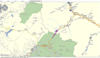
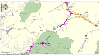
I have a Zumo XT running version 6.5, connected to my Windows computer running Basecamp, version 4.7.5, using the City Navigator 2024 map, and I am getting a route calculation error when attempting a route that crosses from USA into Canada.  I have tried this using two waypoints only to make it as simple as possible, but the error continues.  Please see the attached image.  The only way I could get around it was to split my route by country.  As long as the route was wholly within either country the route would create correctly.  Something that has recently updated has changed to cause this condition as it was working correctly just 3 months prior.

If there is a fix for this or some change I can make to prevent this I would like to know.

Thank you,

Tom Clark
Spokane, WA

  • My guess is that you are using the maps off of your device.  The CN map is split on the device due to file size limitations and BaseCamp (unlike the device) can only access one map at a time.  You will need to download the map onto your computer via Garmin Express.

    If you have never updated the map, the option to install on the computer  may not be present.  In that case, I would try a reinstall on the device and see if that makes the option to install on the computer available.  Others may know a way around this limitation.

  • I have confirmed what  said.  In BaseCamp I can readily create a route between Spokane and Calgary when I use the CN NA NT 2024.1 map that is installed on the computer but route creation fails when using either map file on the XT.

  • As advised this is because the map on your device is split into 2, the solution is to use Express to install the full map to your PC.

  • I have the same issue with route calculation errors as shown in this screenshot, Zumo XT running latest update but this shouldn't matter as I have the map installed on the pc and i'm running 4.7.5 BC. Using City Navigator Europe NTU 2024.1 and attmpting to plot a route of just under 200 miles which I can then alter using waypoints to take the roads I want.

  • Some long/complicated routes can produce this error even if using the map on your PC. Try splitting the route in 2 and see what happens.

  • I have encountered random route calculation errors on my XT when loading routes created in BaseCamp.  Surprisingly, creating a new route that duplicates the problem one, but with new route points, solves the problem.  I have not found a way to identify the specific route point that is causing of the problem.  I will send a route to the XT and then import it.  If calculation fails, I will delete it, recalculate it in BaseCamp, and then resend it to the XT.  If it fails again, I create a new route.  Routes of 200-300 miles are common for me.  They will contain a mixture of via points (some from POI searches), and shaping points.

  • Hello,

    I get the same routing issuesin multiple places with even very short routes on the full map City Navigator Europe NTU 2024.10.

    See the example below.
    The route is 6.4km long and calculated to last 6 minutes :

    Now if I move the second nav point only a few hundred meters away, the route is now 187km and 3h35m long !

    This happens in many alpine passes.

  • This isn't the same issue, many Alpine passes have road closures associated with them, check your BaseCamp settings to ensure Alpine road closures/avoidances aren't selected.

  • Thanks, you nailed it. But excuse me, the closure times are totally fubar. Once the Piccolo San Bernardino pass opens in may, the is no closing time until the first snow...