Combining track

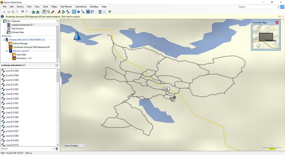
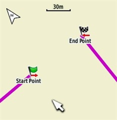
I am trying to combine 111 tracks into one track. The problem I am having when I try to join them it gives me red straight lines to join up the tracks. I understand this is because the tracks are out of order. It will not be possible to put this in any order and I would just like to put all of the tracks into one folder within my gps so that all the tracks are visible and accessible easily.

This is a ski trail route map that will be used by the people preparing the trails. There are many places where we have to switch back on the trail and so on. So all i really need is a way to combine all the short streches into one easy to use file on the gps and in basecamp. Does anyone know ho
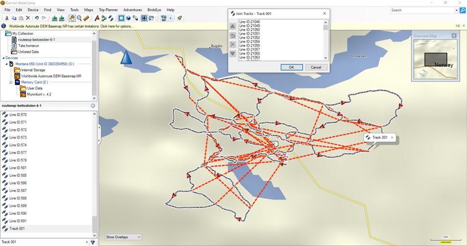
 w to do this?

  • All good points BD. I think you are correct about the Montana 650 limits on the number of track points and tracks. For hiking, a rule of thumb that works for me is that you can get pretty good accuracy with plotting ~250 track points per 10 kilometres, so 10,000 track points is a fairly generous limit.

    If the tracks were originally recorded with a very high frequency e.g. at 1Hz, then the tracks could be usefully filtered in BaseCamp (or GPSVisualizer) to downsample the number of points without losing much accuracy, before starting on the joining process. If the network is going to be plotted manually, this of course won’t matter.

  • A track is a sequence of connected points that must be followed in order

    That's not completely true. A track is a collection of track segments; each segment consists of a sequence of connected points. Those segments however, are NOT connected to each other. I've made a tool that can merge several tracks into one, using separate segments. The description on the page is in Dutch, a translate button can be found top right on the page: https://www.javawa.nl/segtracks.html

    I've tested it with several outdoor models; all of them support multiple track segments. Keep in mind though that the complete track is still limited in the number of points (usually 10,000; 20,000 on GPSMAP 66, Oregon 7x0 and Montana 7x0).

    BaseCamp (and MapSource) do not support this concept; both will put all segments together with interconnecting lines. So don't send the newly created file with these programs to your device, use Explorer or Finder instead.

  • I suppose if I were to get technical I would describe a gpx track as a historical record consisting of an ordered list of positions .  The lines we see connecting points are for our visual benefit. 

    The idea of track segments was likely to indicate a gap of missing data or uncertainty as to whether a new segment belongs with the previous segment (turned device off while I ate lunch) or is the start of separate data set  It is up to the human to decide what to do with the data. 

    From the standpoint of representing a track as a line, the segments would not be connected.  It serves as a visual indication that there is a gap or corruption of data between those two points.  If one decides segments belong to the same "track" or data set, the segments are connected in a navigational sense in that the first point of a new segment is the next position in the availabe sequence.

    From the standpoint of the OPs problem this looks like the perfect solution for their task.

    JaVaWa, what would happen if someone tried to use the navigation function of a device on one of your tracks?  Will navigaion stop when it reaches the end of a track segment or conintue on?   Also, is there or do you know of a tutorial for the gpxtoimg tool?  Finally thanks for all your marvelous tools and I hope all is well with you.

  • I didn't try it live, but I did some experiments though. I created three tracks in random order and joined them together with my tool. After activating the track the GPSMAP 66 displayed in the field "Distance to Dest." the correct distance from my position to the endpoint of the nearest track segment; that was the 3rd one.

    It also displayed these markings at the endpoint of the 3rd segment and the closest start point of (in this case) the first segment:

    (1st on left, 3rd on right)

    There were no markings between the 1st and the 2nd segment, but I guess they will appear when I reach the 1st segment.

    AFAIK there is no tutorial of my tool IMGfromGPX, but it isn't a very complicated application; the info in the help file should be sufficient.

  • Many devices have a maximum number of tracks allowed.  So Garmin users need to combine multiple tracks into one track.

    This can be done by the GPX standard of using track with track-segments or track-segmentation.  Even tracks that do not connect can be merged into one track.  Each individual un-connected track becomes a track-segment within the one track.

    The problem is Garmin does not support the GPX standard of track-segmentation.  This GPX standard is a decade old.

    Garmin needs to get this done.

  • There has never been a standard for the gpx format.

    The elements in the proposed format represented a mismatch of the information that different brands of devices chose to save.  As an example, some devices allowed a "comment" for a waypoint while others allowed a "description".

    As JaVaWa pointed out, devices used track segments as a way of dealing with dead batteries, loss of sattelite connection etc.  The track log on Garmin handheld outdoor devices still use segments in the Current Track log.

    The link that JaVaWa provided (https://www.javawa.nl/segtracks.html) will convert multiple tracks in a single gpx file into a gpx file with multiple track segments.

    BaseCamp will export multiple tracks into a single file.(track will be in the order listed).  JaVaWa conversion will maintain the order.

    IF you try to import the file into BaseCamp, it will convert the track with multiple segments into a track with a single segment.  This will cause a line to be drawn from the end of one segment to the start of the next.

    IF you use the windows file system to copy the file into the appropriate folder on a device, the track will remain as multiple segmented track and when displayed will not connect one segment to the next.

    IF you download the track (with multiple segments) into BaseCamp it will be converted to a track with only one segment just like the import method.

    The current outdoor handheld devices typically allow 200 saved tracks plus an additional 2000 archived tracks.