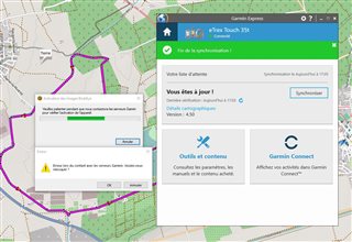
Bonjour Dans basecamp impossible d’ennoyer à l'appareil ma randonnée dans mon etrex 35T j'ai un message d'erreur suivant :
"ACTIVATION DES IMAGES BIRDSEYE" "ERREUR DU CONTACT AVEC LES SERVEURS GRAMIN"
comment faire pour sauvegarder mon trajet???

Bonjour Dans basecamp impossible d’ennoyer à l'appareil ma randonnée dans mon etrex 35T j'ai un message d'erreur suivant :
"ACTIVATION DES IMAGES BIRDSEYE" "ERREUR DU CONTACT AVEC LES SERVEURS GRAMIN"
comment faire pour sauvegarder mon trajet???

Bonsoir!
There seem to be three things going on in the image that you posted:
Hope this helps!
bonjour merci, mais je sais déjà les infos
Un itinéraire tracé dans BaseCamp peut être envoyé à votre appareil en sélectionnant l’itinéraire, en cliquant dessus avec le bouton droit de la souris dans la liste et en sélectionnant Envoyer vers... et en sélectionnant votre appareil, ====> mais cela ne marche pas j'ai le message d'erreur voir la copie d'écran, par contre je peux transférer de l'etrex vers mon ordinateur Windows 10, tout les logiciels base camp et ordinateur 10 et anti virus sont a jour
Ignoring the Garmin Express window, the error messages in the image in your first post relate to errors from trying to send a BirdsEye map to your device, not a route. BaseCamp has no reason to contact Garmin servers at all when sending a route to your device or the mSD card in your device.
However BaseCamp always contacts the Garmin Servers when transferring a BirdsEye JNX file to a device or an mSD card in a device to check that the device has an active subscription. If it can't find an active BirdsEye subscription you will get an error message. In your case server contact may have been interrupted, and it is worth trying again if you do have a subscription. I do not believe either of these error messages relate to sending a route to your device.
If you had a BirdsEye JNX file with the same name as your route and tried to send this to your device, it would account for the observed errors - is this possible? The use of View > Data Filter > All Data will ensure that all data types are visible in the List data window.
What happens if you send a Track or a Waypoint from BaseCamp to your device - does this work?
j'ai pas d'abonnement birdseye.
j'utilise uniquement BaseCamp, qui je trouve extrêmement lourd, mal étudié, et très difficile d'utilisation pour la création d'un itinéraire. impossible de faire une simple boucle sur un trajet randonnée ( comme sur garmin connect puis tableau de bord puis création de parcours ) en un clic sur mon point de départ je dessine la boucle avec le choix de distance de randonnée.
apparemment j'arrive de nouveau a transféré dans mon etrex 35t un trajet, pourquoi cela fonctionne ??? je ne comprends pas d'où était le problème?
maintenant je cherche comment faire une boucle comme dans garmin connect, création de parcours
sinon j'utiliserai garmin connect pour la création de mes randonnées et plus base camp
Well that explains the "Activation des images Birdseye" error.
Like any most complex software BaseCamp does have a learning curve and users have to persevere to use its capabilities. The New England Riders have some excellent training materials https://www.newenglandriders.org/learn-basecamp/ which deal with route creation in a lot of detail.
Just so you know, Garmin stopped further development of Basecamp some years ago, so it is what it is today. Garmin has recently updated a number of its devices to be able to use courses. It is impossible for BaseCamp to create courses like you describe as it never had this capability, and so as you suggest, you will have to use Garmin Connect, which is exactly Garmin's intention.
I have used BaseCamp for over a decade and have never had a problem sending a route from BaseCamp to my devices, so without further information, it is impossible to say why this didn't work for you the first time, but I am glad you were able to send your route to the Etrex.
j'ai eu une aide en ligne par "chat" le conseillé de chez garmin il m'a certifié que basecamp était fais pour les etrex 35T pour la création de randonnée et de ne pas prendre garmin connect pour une création de randonnée. maintenant j'utilise Visorando pour faire mes traces gpx et apres je copie dans la mémoire du etrex.
Yes I agree that BaseCamp will work fine for managing the import of plotted and exported GPX tracks from Visorando and then sending them.to your Etrex. Another viewer/plotter webapp that you might want to take a look at is nakarte.me which has better functionality and a large range of map layers including national topo maps, OSM derivatives and several satellite layers as well as a separate panel for Google Street View alongside any other map layer.
https://nakarte.me/#m=15/43.75199/4.46320&l=Otm/Ft&q=sautebraut
merci pour la reponse