I had an odd occurrence.
I had created a route using Basecamp. Prior to loading the route into my Garmin DriveAssist 51, I ensured each shaping point was in the correct location, by zooming in 100%.
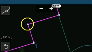
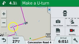
During the trip there were two occasions wherein my DA51 asked me to perform a U-turn, about 300 metres beyond the correct turn location. The on-screen map indicated an extension, beyond the correct turning point. I grabbed a screenshot at one of the locations (image attached). After my trip I checked my Basecamp route as well as the map installed on my DA51. Both maps indicated the CORRECT path with no extension (screenshot of the map installed in the DA51 attached).
The DA51 should have had a clear view of multiple satellites as this was in a rural location. Also, both Basecamp and the DA51 have the same map installed (recently updated to v2022).
Anyone have any ideas as to what would cause this anomaly?