Hello everyone. Can you tell me why the grid lines on the maps on my screen in Basecamp now appear slanting? - my maps seem to have gone skew-wiff! . Thanks.
Thanks for that explanation. I was just wondering how the different settings affect the view of the map. So if the "Align North Up" option always sets the map to True North not Grid or Magnetic North, does it only really do that on the Birdseye Select map at the map datum point as the map is distorted anywhere else?
Not that it really matters for me but the thread opener might need to know. I don't use compass headings or routes for hiking in the UK. I can see that in a featureless desert or wilderness area you might want to follow compass headings. I just use my GPSMap62S (with the Birdseye Select OS25k maps installed) to either record hikes I go on with a group, or to follow a track on the GPS screen that I've create in Basecamp, taking a paper map along to see the overall area.
I would assume that Birdseye data would be like custom maps in that they are composed of 1 or more "tiles" of a maximum fixed sized. The meta data for the tiles will contain coordinates of opposing corners or all four corners. I would guess the former in that multiple images would be stitched together, then distort the larger image to have True N-S run perpendicular to True E-W, then crop the larger image into tiles.
A paper high resolution topo map will also be distorted so that the edges run true N-S/E-W. The legend on these maps will show Grid North and Magnetic relative to True North at the center of the map. It will also provide information on the expected change of magnetic north over time (and yes, the map will have a date associated with it).
In wilderness areas in the US or Canada, you would be wise to carry paper maps and a compass in case something happens to your GPSr. I suspect those of us who were around prior to GPS do, I'm not sure about the those who grew up with GPS.
Thank you BTLAAKE - a bit confusing for a newbie like me - but I am trying to work it out - no luck so far - I don't understand how my map didn't look like that a few days ago. Am working on it. thanks.
When you say the map didn't look like that a few days ago was that in this location or were you looking somewhere else? You can adjust the map orientation using View, Map Controls, On to display a compass on the screen but you will also need to adjust as necessary at other parts of the map due to the way the map is constructed as posted above. There is no setting that will display the lines vertically for every place on the map.
Very strange! I have now looked on QUO (Mapyx) as I used to use maps from that until I bought my GPS Map66s. I haven't looked at that in years, and was surprised I still had an account - I see that the lines on that are straight! So if I need a photograph to put in with my pictures of the location I suppose I can use that. Strange that I did not notice this problem on Basecamp in the months I have been using it. I can't see how to attach a JPEG file of that to show an example even though I did it before to show my problem!
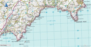
The Great Britain Ordnance Survey paper maps are oriented to the OS National Grid which is divided into 1km squares and each map edge is aligned to the grid lines (the blue lines shown on the opener's image), not True North/South or East/West. Each map specifies it's variance from true north at it's centre and the variance of True, Grid and Magnetic North. So each grid square is 1km square. Instead of using Lat/Lon co-ordinates, for most land base activities, Grid co-ordinates are used. So the Victoria Monument outside Buckingham Palace is at TQ 291 797 accurate to 100 meters or TQ 29156 79738 accurate to 1 metre.
The Memory Map mapping I use on PC and phone is aligned and displays the same way as the paper maps with the grid lines square on screen.
The Garmin mapping on PC and on my GPSMap62S displays with the grid lines distorted for the reasons you've described.
Anyway, thanks again for your explanations. I thought it was all done with magic!
To 8250673 -- Decipher the above explanations as best you can. Different mapping systems have different ways of projecting a map of part of a sphere (the Earth) onto a flat surface. Your Garmin map is still correct. Yes, the image you posted does not match the paper map for that area. But if you are using the same map on a Garmin GPS, the area of the map you can see on screen at any one time is so small the distortion won't be noticeable. Try zooming in on your PC and you will only notice any distortion if you look at the grid lines. The grid references, headings, distances, etc., will all be correct.
To 8250673 -- In addition to using the compass to rotate the viewed map as mentioned previously by SUSSAMB, on my laptop these keyboard shortcut allows you to rotate it in 5 degree increments a bit more easily:
Thanks - good tip. Is that documented somewhere or did you find that by accident? Don't know if this also works on a laptop keyboard but on a standard keyboard without the "Fn" key Alt + Home and Alt + Page Up works.