Create a route based on 2 points, does BaseCamp add a 3rd point? Can someone verify?

Former Member
Former Member

Hello,

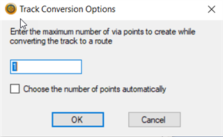
I'm new to Garmin BaseCamp (Version 4.7.3 Windows) and today I tried to create a new route selecting 2 waypoints that are showing on the map. This would be basically create a line for a boundary over water so I select offroad-direct or shortest. I noticed after the two points are added to the 'New Route' window and I click 'Go', the two points show up in the route window. Can I then create a route or do I have to create a track first? When I click 'Create Tracks', I now see there is a 3rd point in my route properties. I do not want this point, but only want the route to be created from 2 points. However if I delete that 3rd (middle) point, it will not let me create a route. Instead a 'Track Conversion Options' window pops up wanting me to at least include 1 point. The window asks "Enter the maximum number of via points to create while converting the track to a route". Does this mean the BaseCamp software is selecting a 'middle point' between my original two waypoints?

We also noticed today that the route will vary with the same 2 waypoints, just by changing which one is the start and which one is the end waypoint. Is this because of that middle point being added?

This is for ground verification and I need to feel confident in how the software is creating this route between the two waypoints.

Thanks so much for the clarification!!,

Kathy

Top Replies

All Replies

  • Provided it's a straight track I'm not sure what your issue is?  I'm also confused as to what you want to use, are you trying to create a route or a track?  If you're simply trying to create some straight lines to follow a boundary just create a route using the direct activity in BaseCamp.

  • Former Member
    0 Former Member over 4 years ago in reply to SUSSAMB

    Thanks for the reply. I can understand on the confusion. I am working with someone that uses BaseCamp to input routes into their Garmin GPS and typically uses routes. We are looking to verify a few new coordinates, so yes the main thing I want is a straight line between two waypoints to visualize in BaseCamp how this new coordinate aligns to existing boundaries.

    I've done as you said created routes based on 2 points, but while the routes are created I'm observing strange behavior and believe the software adds an additional point to the route when it is created.

    For example, I create a route and then I invert the route and now the route is different or moves about 30 feet either east or west from the original route I created. If a route is between two points shouldn't it be the same whether it starts at point 1 or point 2?

    I've also noticed that if I create a track from my route, the track then shows an extra mid-point inserted between the two original waypoints. I've attached screenshots. This is misleading on the route and comparing with existing boundaries because if I remove the middle point inserted by the software this impacts the line and its path/relationship to adjacent boundaries. 

    Lastly there is a window if you try and create a route that shows up. Can someone clarify on what this asking? To me its asking how many additional points I want to create in the route between my original 2 points. I only want a start and end point. This will be input for a GPS for flying over the boundary. However if the software is adding in a 3rd point when it creates a route, this is not something I want but I do want to verify.

    I do not understand why the route between two points would be different based on its direction (inverted). I also do not understand on that additional point that shows up.

  • You're making life difficult for yourself and as I'm not looking over your shoulder it's difficult to follow exactly what you're doing, and there are too many variables to make a guess.  If you simply want a straight track or route then a track will go where you want it, as will a route if you select direct activity. Now, the real point is how this will work when you transfer it to your device, but as you don't mention which device I can't advise further until I know.

  • Former Member
    0 Former Member over 4 years ago in reply to SUSSAMB

    I've selected direct activity for the route. I'm just trying to troubleshoot the issues we are seeing in the software itself and different routes that are showing. My work is not difficult, I'm trying to create a direct line between two waypoints. So why is that route different depending which starting point I use or invert it. The route moves 30 feet to the east or west? 

    The 30 feet might not seem like a big deal but if the software is adding a 3rd point when it creates a route this could be what is causing a 60 foot shift in the line compared with the other mapping software I use. (Esri desktop software).

    I don't what know what GPS unit the field crew is using, I'm just trying to help understand these differences we are seeing in the BaseCamp software.

    Currently I do not understand the differences on the lines the software is creating. For instance if anybody else created a route between two points convert it to a track, there will likely be an extra point as I showed earlier. This is actually really important because the trajectory of the line will be different over a 17 mile distance we are looking at.

    I'm not trying to make it difficult but I need to understand what the software is doing. A route if it truly consisted of only two points when inverted shouldn't move east or west of the original route. I appreciate your insights.

  • Seeing the initial Route Properties window would be helpful.  When you made the initial Route with the Direct profile you should have seen only two points in listed in the Route Properties window (ignore the summary area).  If you click on the Directions tab, you should only two points.  Is this what you see?

    The creation of a track from this route will add a point between the start and finish.  The middle point can be deleted from the Track Properties window by selecting it and pressing the delete key or using the eraser tool on the map.  Or you could click on the filter key and set a maximum number of points to 2.

    I'm not clear on what you are seeing when you mention the shift.  When Garmin devices or BaseCamp calculates a distance or course it is using a Great Ellipse calculation.  I would not be surprised that when they added the point to the Track that this point is somewhere along the Great Ellipse arc between the start and finish points you provided.  To put it another way, the added point is not on a direct compass heading between the start and finish point.

    I am guessing the shift you mentioned refers to the three point tracks made from two routes where the start and finish points were reversed.  Since the point added during Route to Track conversion is not midway between the start and finish, if the point is on the Great Ellipse arc, you might see a shift in the two 3-point tracks.  But, as I wrote earlier, just delete the middle point and you will be fine.

    Regarding the Track Conversion options, recorded tracks can contain up to 10,000 points.  Routes on Garmin devices are limited to far fewer points, so culling is necessary if you wish to use the converted route on a Garmin device.

  • Former Member
    0 Former Member over 4 years ago in reply to BTLAAKE

    Thanks so much for the great info. A little more info for why the difference matters, is I'm trying to see how close a route/track line is to an existing line that includes the point.

    My process, I create a new route based on the lat/long shown in the route properties in the screenshot below. The properties do show only 2 points and the new route displays.

    Without converting the new route to tracks, I click 'Invert' and this moves the route approximately 30 feet to the west. The original route is shown in pink.

    Next I create a track from that inverted route. You are correct I do see now 3 points with the new one in the middle. But the track shows the same as the inverted route.

    I delete the middle point from the tracks and you would think this would look now like one of the routes? The track properties show only two points, but now my track line shifts another 30 feet and actually is where I would have thought it should align based on the other GIS mapping software I use.

    Now when I click to invert the track line, the track line does not shift, but just the direction as you would expect from a line based on only 2 points.

    Now the track line properties and route properties look the same with only those 2 points showing, but based on what I see here I would only trust the track line. The route even though it does not show an extra point must have it which would explain the offset routes depending on which starting point of the route. The original route and is ~60 feet east of the track line. The yellow line is the inverted route and is ~ 30 feet from the track line.

    Thanks so much again and this has definitely been a learning process. I look forward to any other insights/findings you have.

  • While this is no doubt an interesting discussion about what is happening when you take certain steps I do feel you're overcomplicating it. It would also help if you said which device you want to use it on, as some can't even accept tracks so you would need to stick to routes. 

  • Former Member
    0 Former Member over 4 years ago in reply to SUSSAMB

    I will find out on the device. All I know is we are trying to figure out differences in the how the software creates the routes since this is a typical/desired workflow to use for field work planning/navigation. When verifying features on the ground the software showing differences of being of ~30 - 60 feet is important to understand why. For instance, why should there be any difference in a route depending on which direction it is created. This would be really good info to relay to the field crew. I will follow up on the device, but I would appreciate further info on differences we are seeingin the software itself and route/track accuracies, this is really important as well.

  •  - LOL, I’m not sure the discussion is that interesting, but it does apply to how BaseCamp does things.  I would rather have them decide whether or not they can accomplish the required task than wait for one of us to get a firm grasp of it.  Hopefully, they have aware of the limitations of consumer GPSr.

    Former Member  – Kudos for investigating this before giving an OK.  I played around with BaseCamp and I think I have a handle on what is happening.  I will provide an example for you to follow.

    Create waypoints @ N58° W158° and @ N58° W168°

    Create a Direct Route using these two waypoints.

    Convert the Route to a Track – it will overlay the Direct Route

    Convert the Track to a Route – It will also overlay the Direct Route but with addition points added.

    Delete all but the first and last points in the Track – this will give you a track the does due E/W and differs from the routes.

    It appears that once a Direct Route reaches a cut-off length BaseCamp will try to create a multistep route that will mimic a Great Ellipse arc.  You should be able to see the curvature in the Routes vs. the Track.  These intermediate points don’t show up in the original Route, but do show up when converting the Route to a Track and are added to the Route when converting the Track to a Route.

    To illustrate that a Route can be created with additional waypoints to follow a constant course, you can use the move tool on the 2nd Route with multiple added points and drag the first 3 or so down to the Track line.

    Navigating a Track would be the first choice.  Create the Route, convert to a Track and remove all intermediate points.

    If a Route must be used, Create the Route, convert to a Track and look for legs ~11.2 miles or more points in the track than in the route and add additional points as needed.  If a high degree of  accuracy is required for the additional points, an online calculator like the following might be useful: https://geographiclib.sourceforge.io/cgi-bin/RhumbSolve

    Use the Direct function with a start and finish to obtain a course.  Then use this course with the start point and a distance less than ~11.2 miles to obtain an intermediate location that needs to be added to the Route.

    Hope this makes sense to you.

    If your still confused as to why the Route was moving with inversion, it is because BaseCamp was removing the invisible point ~11.2 miles from shore A and creating a new invisible point ~11.2 miles from shore B.

    Edit:  One more thing, there is no guarantee that a Garmin device will do things the same way as BaseCamp.  You should verify what happens on the device.

  • Former Member
    0 Former Member over 4 years ago in reply to BTLAAKE

    Thanks so much BTLAAKE for all the great info on the routes and multistep route. I will look into modifying the tracks to routes since I think routes are preferred. This is exactly the info I was looking to find out on the BaseCamp software and the differences in routes/tracks. Thanks also for the heads up on the Garmin device and we will look into verifying that. Thanks!