This discussion has been locked.
You can no longer post new replies to this discussion. If you have a question you can start a new discussion

Map Updates for Errors?

Former Member
Former Member

I cannot seem to get an answer anywhere else, so please move to a more appropriate area as needed.

So with every map update, for whatever strange reason, my area seems to be a magnet for bizarre map problems where it refuses to allow a route to go through invisible and non-existant blockages. Note to the peanut gallery, this has nothing to do with avoidances - this is absolutely map errors.

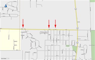
This most recent update included these issues in the sample attached.  There is no way on my end to correct this obstruction, and Basecamp requires a detour.

You report these using the Basecamp Report Map Error function, but you never get a response. And it's hit or miss whether the issue is fixed with the next release.  But worse, even if there is a fix, you end up with a new issue like this that pops up out of nowhere somewhere else. This is a never-ending battle

I put arrow points on this sample so you can see the issue. It's a formatting thing of some sort. Due to the amount of time it takes to fix these, essentially for a Zumo, it extends the entire season, I think whatever this is should be correctable by the end user on their OWN installed map.  Essentially be allowed to erase an erroneous barrier that is negatively affecting the routing.  I know wish lists around here are right up there with asking for winning lottery numbers, but come on.  If you cannot fix a map and send out a fix in a couple of days like most maps, at least empower the users to fix the stupid stuff that shouldn't be showing up in the first place.

Thoughts?
 

  • Not sure what error those arrows are meant to signify but map errors can be reported directly to HERE as they are the company that supplies the map to Garmin. 

    Would help though if you could say what map you're talking about and where that screenshot is?

  • I have those symbols (look like a green "(" or ")" ) on my 2014 NA map, but they do not prevent me from creating a route of just west of I-94 to just a little south on 32/137 using different profiles (driving, motorcycle, trucking or rv).  They do not appear to be related to avoidance.

    Based on their location, my guess is that hey may be related to the Wisconsin/Illinois border.  The road appears to run right on it and may be shifting from one side to the other.

    I realize that doesn't address your issue and I have no explanation why the routing doesn't work for your map.

    (The road in question is along the Wisconsin/Illinois border just west of Lake Michigan).

  • Former Member
    0 Former Member over 5 years ago in reply to BTLAAKE

    Sussamb - If you click on the map, so it expands to full size, you can see on 1st street, little gray outlines of sausage shaped outlines.  The routing function will NOT allow you to drive through those.  I have reported these kinds of things within the Basecamp Report function countless times over the years, and on the Garmin website, and like I said, you never get a response, and by the time someone fixes it, it's generally after the season ends. When you have quarterly updates, and only a fraction of the fixes get covered, for a seasonal user, whenever you see these things, it's typically resolved NEXT year.

    Whatever the heck these are, users should have the ability to erase/fix their own map from these kinds of things that keep popping up out of nowhere. Extremely irritating.

    BTLAAKE, this is essentially Russell Rd, east of I-94 coming up to Sheridan Rd, which in IL is 137 and going north in the WI is 32.

    Yes, this is a route that I've had for many years that is the start point for my group on to the Lake Michigan Circle Tour, and has been fine all these years, and as you mention on your 2014 NA map is works right.  For whatever reason, some block head made a change to the map that makes no sense.  I'm seeing this in 2019_10 which is the most current map.

    Again, what's upsetting is, there have been zero changes in this area so these kinds of things popping up, with the glacial time to fix, at some point, if they cannot prevent these things from happening, they need to allow users to at least fix their maps.

  • Well there's no way to allow users to fix the map as you put it, users can submit corrections. Whether HERE will accept it depends on whether they agree with it or not. Your best bet is to contact them. Having used Garmin maps for around 10 years I've rarely had a routing issue due to a map error.

  • Former Member
    0 Former Member over 5 years ago in reply to SUSSAMB

    LOL, you rarely run into map errors?  Well, I've been using Mapsource and BaseCamp for 15+ years at least and not only are the maps riddled with hidden little gems, but the app itself is cruder than MS Street & Trips from 25 years ago. But you know that. I've been riding cross country for decades and was one of the first to pick up the 550, then to the 660 and so on. So I run into map issues all the time.

    Clearly you don't have an answer, but if you want to keep posting HERE, perhaps you can check your link that is not working.  Better yet, just cut and paste the actual link please?  Is it a Garmin link that I've already been using, or a link to the actual map maker? The later would actually be preferable as they might have user editing tools. Thanks.

  • Former Member
    0 Former Member over 5 years ago in reply to SUSSAMB

    Nevermind, I found HERE myself.  For the others, this is the link:  https://mapcreator.here.com.

    Now what is interesting is, I looked at this same area on their map, and there are NO obstructions:

    https://mapcreator.here.com/?l=42.4918,-87.8337,16,normal#join

    The road is perfectly navigable.  So this appears to be a Garmin issue. Back to square one.

  • Then perhaps try calling Product Support, these forums are mainly user to user help. I'm surprised if you've been using BaseCamp for a while you don't like it. I use it, and have for many years, first with a 1490 and an Etrex Legend, now mainly with a DriveSmart and an Etrex20. I use it to plot hiking and driving routes, with both Garmin and OSM mapping. For a free program it does all I need, and I haven't found another free one as good, but you do need to take the trouble to learn how to use it.

  • Former Member
    0 Former Member over 5 years ago in reply to SUSSAMB

    Sussamb - Clearly you are a Garmin cheerleader, and benefit directly or indirectly for your presence here.

    If you don't think that the enormous upcharge you pay for a Zumo doesn't compensate for the FREE software, I don't think you are looking at this realistically.

    Without the FREE software, the overpriced hardware would be worthless.  So don't fallback to justifying crude and old app technology because it's FREE.  That's like saying the handlebars on your new motorcycle is free. Makes no sense.

    I already gave you an example of an app that back in the mid-90's that still runs circles around MS and BC.  Suggesting this is cutting edge is crazy.

  • Let me first correct your first mistake,  I benefit in no way from my presence here, but I hope others do as I have a reasonable bit of knowledge about Garmin devices and software, gleaned over many years.

    Your second is that the hardware is overpriced.  If you think that feel free to try elsewhere, I assume as you haven't you're happy to pay the price.

    Third, yes BaseCamp is free, many folks own Garmin devices and never come near it.  It's not needed to use Garmin devices and as I said earlier, you don't need to use it so if you know of a better one then use it.  I in the meantime will stick with BaseCamp as it does everything I need, both for my vehicle and handheld devices.

    Fourth, I never suggested BaseCamp was 'cutting edge'.

    Anyway, you now have the closest you're going to get to an answer here, you need as I said to raise this directly with Garmin if the map on the HERE website isn't what you're seeing.

  • Former Member
    0 Former Member over 5 years ago in reply to SUSSAMB

    The point is Succamb, I did go to "HERE" and checked that exact stretch of roadway, and it's perfectly fine there.  So, if in deed Garmin is pulling the maps from there, you are then confirming Garmin is responsible for creating these glitches. I'm glad you rarely run into these, but I proved they exist and you are welcome to check it yourself.  If there was a way to document all of the goofy map glitches I've reported over the years, I think even you would be surprised.

    You can deflect all you want, but saying BC is beyond reproach because it's free is silly.  Its a mission critical feature for Zumo owners as it would be ridiculously difficult to create a 1,000 mile custom route on the device itself. As such, it is part of the package and is absolutely not free.  The fact is, Garmin over the years has put a little as possible into MS and BC, and it shows.

    You don't have to agree, but you cannot excuse the glitch posted above. They DO exist.