Wrong track distance on graph of all partial section of the track

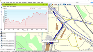
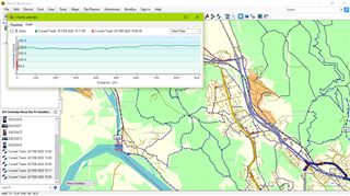
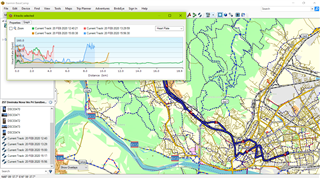
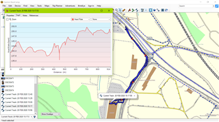
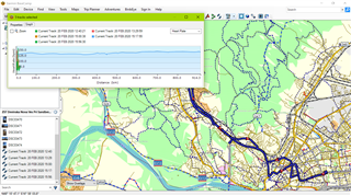
 The track is divided into five sections. Graphs of all individual sections are OK. But when I select all of them suddenly it seems that the distance data on one of these tracks are wrongly interpreted and displayed in kilometers instead of in meters.

I was trying to post .gpx files by copying them here - there was a message Upload file(s) but I cannot see any of them

OK I got it - just images  - four tracks are longer than 1 km, one - the "offending" - track is long less than 1 km - distance on an individual graph of this track is in meters but on the graph where all the tracks are selected and opened together meters are interpreted as kilometers

"offending" track


  • If you still have the track log, try saving the tracks to individual files on your device before downloading to BaseCamp.  I would also check to see if the offending track and just one of the others causes the same issue. 

    I tried six tracks with a total of more than 10000 points and it worked on version 4.6.2.  You should report this to Garmin Support.

  • Thank you for taking time and testing. 

    Yes, I always save all track logs on my computer first - I do not use the direct access BaseCamp - Oregon 700. I will report this to Garmin Support. The issue is due to the mixture of tracks longer then one kilometer (they determine the scale in km) and the track of length less than one kilometer - that graph displayed alone will be measured in meters - 

    the graph of mixture of only one track longer than one kilometer (standalone scale in kilometers)
    with the track of length less than one kilometer (standalone scale in meters)
    when the last one is displayed together with the track longer than one kilometer (scale in kilometers) 
    its values are mapped on that kilometer scale (its scale units are not recalculated)

    the same with another track log

    without the track less than one kllometer graphs of all tracks
    (of the same scale) are displayed correctly

    this graph is using different scale (in meters)

  • After giving this some more thought, you are seeing what I expected.  BaseCamp will change units for an individual plot from m to km or ft to mi (actually it's m to ft or miles) based on the total distance.  The distance tables themselves are just numbers (converted based on the distance of a particular track) and the units shown on the plot (m or km)  are chosen based on the the first track selected.

    You can verify this by making a duplicate of  the offending track.  Select it and use the move tool to move the first or last point so the total distance is greater than 1 km and try your multiple plots again..  You can then try moving it back to give a total distance of less than 1 km and retry the plot.

    When you contact support explain to them that the issue is viewing multiple plots where the individual plots are in different units due to a conversion from m to km for some of the plots.

  • Wrong distance on graph display was finally acknowledged by Garmin support as an error in BaseCamp and it was passed to software engineers for further investigation.