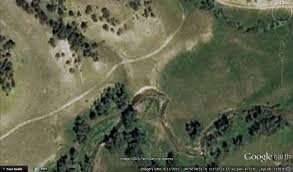
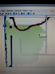
In my line of work, I'm constantly using Google Earth on my cell phone. The problem with that is there are locations where I don't have cell service. I recently purchased a FR945 and thought using Birdseye Satellite Imagery would solve my problem. I decided to preview Birdseye with Basecamp before purchasing a subscription when I ran into the following issue. It doesn't matter what area I select to preview, but I always see an image like the one on the left (it becomes distorted when I zoom in) when I expect an image like the one on the right. I've tried this on two laptops with the same results. Am I doing something wrong here? I don't want to spend $30 on Birdseye if the left image is what I'll see on my watch. Thanks in advance for any assistance.