Basecamp Route instructions mileage listings round to nearest mile after 100 miles

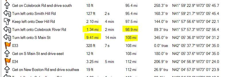
I need to see the mileage reported to the nearest 0.01 mile as the incremental miles so. Once the total running mileage of 100 is reached it rounds to the nearest mile.

Any idea why, or how I can remedy this?

Anyone know how to export the route instructions into an Excel file with individual cells for the time and distances.

We need this for the final planning stages of our 700 mile Historic Rally.

Here is some info on the event in case you are interested:

Automotive rally teams from the northeastern U.S. and beyond will gather October 12–14, 2018, to challenge their cars and themselves in a 700-mile Revival of the Great American Mountain Rallye (GAMR), a European-style endurance event that was held annually from 1953-1957 in upstate N.Y. and New England.

For more information on the Historic Rally an where to register please follow the links below.

https://stevemckelvie.wordpress.com/?s=GAMRR

SCCA Registration page:

https://www.motorsportreg.com/events...adrally-899014

Note:

The start is now in North Salem NY:

https://goo.gl/maps/G1Z3z2M8KC52


Thanks
[IMG2=JSON]{"data-align":"none","data-size":"full","src":"https:\/\/ssl.gstatic.com\/ui\/v1\/icons\/mail\/images\/cleardot.gif"}[/IMG2]


ciq.forums.garmin.com/.../1398617.jpg
  • Former Member
    0 Former Member over 6 years ago
    Macular degeneration notwithstanding, one could look for the slide rule. Then slide the left (or right) index of the C scale over 5280 on the DI scale (if any) to convert feet to decimal miles. Then take a #2 Ticonderoga pencil (sharpened with the Boy Scout knife) and record the data on the existing route printout. Add digits to the printout as required and copy for distribution to participants. Hmm. Had the copy machine been invented in 1956?
  • Yea, old school analog!

    Actually we are only using the Garmin data to QC (blunder check) the actual calibrated mileages and written route instructions we have collected utilizing a precise wheel driven Rally odometer that reads to 0.01 miles.

    I actually did spend a few months retracing the original route, from a paragraph style document and original 1954 Mobile Gas maps with no mileages given. I used Google Earth, Google search engine to find places and finally imported into Basecamp so I could upload it to my trusty 2610 and follow directions with that and add/update road name changes and re-alignments.

    it's been quite a challenge and we are finally heading for the home stretch!

    We actually approached Garmin last Fall for some minor sponsorship and tech support, but they were not interested. Im guessing the automotive side of their business does bring the revenue that marine and sports does.
  • You could select the first point on the route directions tab, type ctrl-a, ctrl-c and paste it into excel. You may have to use the text to data conversion under the Data menu using comma as a delimiter to convert to columns. This can be messy, but the Distance column should be aligned.

    A formula like "=IF(RIGHT(B2,2)="ft",VALUE(LEFT(B2,LEN(B2)-2))/5280,VALUE(LEFT(B2,LEN(B2)-2)))" would convert a distance in cell B2 to miles.
  • Former Member
    0 Former Member over 6 years ago
    If I am permitted, I will suggest that the discontinued Delorme Street Atlas.Topo apps can contain up to 100 user entered waypoints per route and output arrival times in hours, minutes, and seconds. Mileage to turn points can be printed in hundredths of miles. Internally calculated turn points can exceed the 100 point limit, but only the first 100 turn points of each route segment can be exported in gpx format. Yada, yada.

    If the available waypoints for the Garmin Basecamp rendition can be supplied to forum users it may not be too difficult for an experienced Delorme user to massage the road vector lengths as required to give a matching result from a Delorme app.
  • Former Member
    0 Former Member over 6 years ago
    Convert the route to a track and copy the track data to a spreadsheet.