Creating Custom Map

I currently have a Legend Cx, but I am looking really hard at the GPSMAP 64st. Will probably purchase in the next week or so. I mainly use my Garmin for hunting/hiking. I do alot of hunting on public land and in order to not cross over onto private land, I use my handheld along with .gpx files.

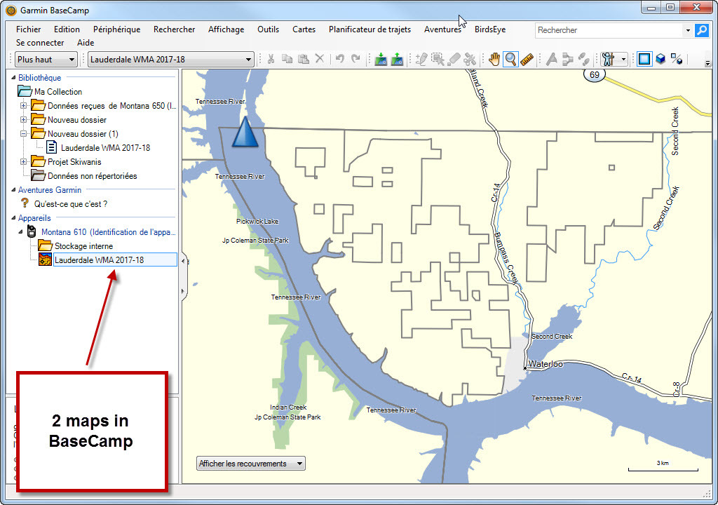
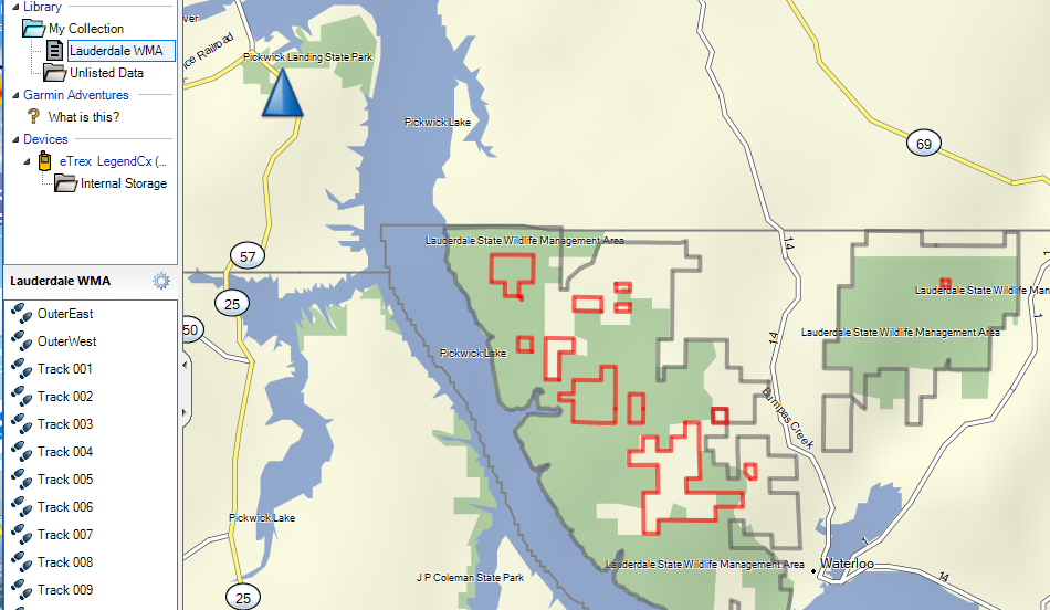
The problem that I have with ,gpx files is that they import into BaseCamp as tracks. (I get the same results wihen I import into MapSource). What I would like to do is convert these tracks into "Boundary Lines". Many times for a given wildlife management area (WMA), there will be small pockets inside the WMA that are private lands. Is there a way to make this new map have one name and when it is loaded/shown it will show the outer boundary and all the smaller pockets inside as well?

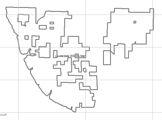
Attached is the .gpx file when I look at it with a .gpx viewer. Notice how the section is broken up into small pieces.

Thanks.


ciq.forums.garmin.com/.../1331293.png
  • I ran the .exe and now I can see the map in Mapsource... but no luck in BaseCamp. Only reason for this was just so I could see the map since I don't have a gpsmap 64 yet. I tried to send the map to my Garmin legend, but got an error.

    Thanks
  • I ran the .exe and now I can see the map in Mapsource... but no luck in BaseCamp. Only reason for this was just so I could see the map since I don't have a gpsmap 64 yet. I tried to send the map to my Garmin legend, but got an error.

    Thanks


    The installer worked for Basecamp for me.

    I could make my map visible in Basecamp using another Javawa program.

    The Garmin Legend has a paltry 8MB of memory. That's not enough to really do anything with maps. It's not surprising you got an error.
  • The installer worked for Basecamp for me.

    I could make my map visible in Basecamp using another Javawa program.

    The Garmin Legend has a paltry 8MB of memory. That's not enough to really do anything with maps. It's not surprising you got an error.


    What JavaWa program did you use to make it visible in Basecamp? Can you show multiple maps in Basecamp or is it just one map. I would like to be to have my map as an overlay so I can see the topo basemap also.

    What did you use to create the .img file where you edited and removed/added lines to the map?

    Kirk
  • Anyway it's already done
    Here is the map, it settles in BaseCamp


    Can you tell me what you used to create the .exe installer?

    Thanks
  • Hi KArthur

    I use Inno Setup to do the installation program.

    You can display 2 maps at the same time in BaseCamp.
    One Topo map and the other transparent map.

    In Mapsource select the 2 maps and send it to a USB stick in the Garmin directory.
    After rename the file gmapsupp.img in the Garmin directory to gmapprom.img
    In BaseCamp choose the USB stick and you will see the 2 maps at the same time.ciq.forums.garmin.com/.../1332895.jpg
  • What JavaWa program did you use to make it visible in Basecamp?

    The "device manager" program. You mount the drive with the maps and run the program. Then, click on "Manage maps".

    Highlight the map and click on the Basecamp circle icon at the upper-left. This program also lets you change the internal map names.

    Can you show multiple maps in Basecamp or is it just one map. I would like to be to have my map as an overlay so I can see the topo basemap also.


    It's one map.

    Basecamp doesn't let you display two maps at the same time.

    Scdigps appears to be copying the topo map data (for the region of the wildlife area into the border map he created. That is, he's combining two maps into one map (one map has to be transparent).


    There are certain types of "image" (raster) maps that work as overlays.

    Here's another way to get the tracks to display in Basecamp on another map.

    In the "Library" at the left in Basecamp, create a folder and import the tracks into it.

    Create another folder for this "project" and move the above folder into it. That way, you can display the border tracks and the routes/tracks for your "trip" at the same time.

    I attached my version of the cleaned-up border tracks.

    What did you use to create the .img file where you edited and removed/added lines to the map?

    I used Javawa's IMGfromGPX (which I described how to use). It's really easy to use.

    I uploaded the wrong file. I reattached the correct file. This file contains the tracks (not the map).
  • You can display 2 maps at the same time in BaseCamp.
    One Topo map and the other transparent map.

    Hmm. That doesn't work for the "City Navigator" or "Garmin Cycle" maps. Does your map file contain a raster image?
  • Hi dpawlyk

    To make it work, one of the map must be transparent

    See video here https://1drv.ms/v/s!AlrtCHHWCApwgwty1iysL5bx40u9


    Yes, I know it has to be transparent. Javawa's imgfromgpx creates transparent maps.

    My French is terrible.

    It looks like you are using Mapsource to copy the topo map into the border map.

    This is not letting Basecamp use two maps.

    It's creating one map from two maps (one is transparent and the other is not).
  • DPawlyk,
    I really appreciate the time you have spent on this and I downloaded the .gpx file in message #20 above. Brought it into BaseCamp. What I am wanting to do is when I bring in the map, I do not want the map to be TRACKS as they are shown in the browser on the left. I don't want to be able to navigate around those places. I had rather those tracks be just lines on the map like other boundary lines, roads, topo lines...etc. Is it even possible to do that?

    That was what I asked for in my original post and it might not even be possible.

    Thanks

    ciq.forums.garmin.com/.../1333167.png
  • I had rather those tracks be just lines on the map like other boundary lines, roads, topo lines...etc. Is it even possible to do that?


    For the GPS device, you don't need to do that since the newer GPS units allow the use of overlay maps You can use the *.img file that I attached in an earlier post for that.

    For Basecamp, you can use other programs to merge the two maps to create a new map. scdigps showed (in a video) how to use MapSource to copy the topo regions to the border map to create a new map. There are other ways of doing that too.

    Another approach, which isn't quite as easy to use but it easier to do, is to use the tracks that you loaded.


    The way to do that is to create a folder for this "Project". Then, create a folder in that folder and move the border tracks into the folder.

    Then, do your work in the "Project" folder.

    This approach isn't perfect (you won't see the borders all the time) but it's easier to set up.