Forcing Basecamp to follow a specific route

I have been working on a retracement of a historic auto route for the past few months. It is almost 1000 miles long and it is important that it follow the original route.

After giving up trying to force the route (it would constantly change based on the routing profile) I created a track in Google Earth. I used Earth because I needed to see some streetview data and information like covered bridges.

Once I created 4 tracks by locating numbered route instructions (waypoints) I traced between them with quite a few shaping points (Google Earth points).

Once I was fairly happy with the tracks I imported them into Basecamp along with the waypoints.

I then created routes from the tracks, but still had to adjust a number of places, sometimes the route would double back because the waypoint was slightly off the road.

I also reviewed the route directions and made sure all the waypoints were in the correct order. I rubber banded the routes where it ran in the wrong direction.

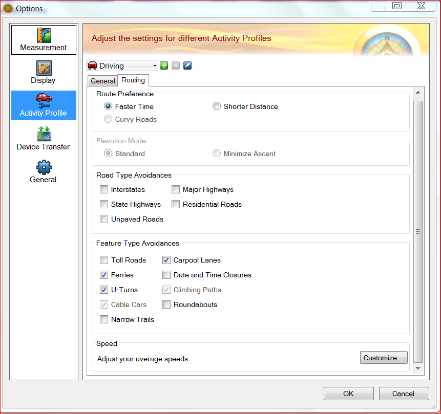
I had the Routing set to automobile and had U turns, ferries and carpool lanes as avoids. (I had it on fastest route, no option to have none on that setting).

I am confused that the route does not stay on roads, as I thought it would. This makes review of all the shaping and many many waypoints difficult. The route instructions do not say "leave road".

Once I get the route exactly where I want it how can I "lock it" so it does not change.

I did recreate tracks from those routes as they never change, but they do not allow me to run routing directions.

This is very frustrating, once I think I have a good portion of the route good I save it, so I broke the overall route into 5 sections, or legs.

Once I have the route correct I am going to upload into my 2600 series unit so we can do a reconnaissance and drive the route to make corrections or notes for when we have the group run it latter this year.

Any help would be appreciated.

ciq.forums.garmin.com/.../1291306.png
  • Sorry but I'm not sure what you're asking. If you've set shaping points, rubber banded etc then it'll follow the route you want but you seem to imply it then goes 'off road'. How? What map are you using?
  • Former Member
    0 Former Member over 6 years ago
    Try deselecting Avoid U-turns, and then ignore the U-turn warnings when they occur as you drive. Otherwise the device will try to re-route you around the block or back to some previous point that it, the device, deems on-vector snap worthy. Accept the fact that the device is going to think it is off route occasionally and still try to recalculate as you travel forward. So you may still need to have hundreds of shape points. If the device is a post 2013 model, it should be able to create as series of 29 point routes in sequence.

    You could try the option of using shortest, not fastest. re-calculation option to see what happens, but don't customize the road speeds in Basecamp if using "fastest" routing option unless your device recalculation can be disabled. Keep in mind that most others in the caravan will have basic devices that will continually recalculate.

  • City Nav V8, Basecamp 4.3.3.

    So, I may have misspoke about off road, that was an earlier issue, but why do I get the route running in the right direction for miles, then it runs back along the route and back again?

    I can see 2 direction arrows and the place it runs too appears to be a node, or point that sometimes I did not insert; other times like in attached example I have a RI (wayoint) along the route with no change i direction, just a "helper" and it seems to run back to it?

    I'll also show a spot that for the life of me cannot get it to run around the block and back onto the route.

    See attached.

    Finally, if I upload the route to my 26XX unit I assume I need to have all the routing options the same? Is there no way to force the unit, no matter which one to keep the route as I have it set?

    See attached.

    Thanks for your help!

    This is going to be for a Historic TSD - Time Speed Distance Rally we are putting on that first ran in 1954 in New England.

    P.S. I am a Land Surveyor, work for large engineering firm and have been using GPS since 1988, Garmin since about '92, still like the flexibility of the 26XX series, even though can't update the maps.ciq.forums.garmin.com/.../1291363.png
  • Doubling back is almost certainly caused by placing a point on the wrong side of a dual carriageway. Zoom right in and change it so it's on the correct side. If you find that isn't the issue post back and I'll look at that map area in more detail, if you can say roughly where it is to avoid me having to input lat/long :)

    Note it appears you're using a BaseCamp version and map that are both well out of date, although that won't change the advice given above.
  • Former Member
    0 Former Member over 6 years ago
    Upon further review it seems that a Street Pilot "2600 series" device may be in use. Year 2005 pdf manual is still available for download, but I am not going to try to understand it. The device may have capability to select certain road preference categories, but may not be strictly compatible with default options in newer devices and thus Basecamp.

    Or the map may just be in error and fails to connect the 2 way road vectors that are the issue of this thread.

    Try detouring around the problem road segment to see if this will force the device to stay on the desired higher (faster) class roads. Or just reset the category options to default. Good luck.
  • roverguy

    OK, I've now looked at your routes using BaseCamp V 4.6.2 and the latest CN NA map and everything behaves as expected, I don't get the doubling back that you're getting on either of the routes/areas you provided screenshots for. So either you have some misplaced points or it's caused by you using a map that is out of date.
  • Former Member
    0 Former Member over 6 years ago
    ORIGINAL Poster - Thank you for the trip down memory lane. I think I may have viewed a Street Pilot device once upon a time 16 years ago in a big box electronics store in Sacramento, California. Then I saw the price and drove the 500 miles back home the same way I got there - by looking out the windows.

    New maps are not available from Garmin for the old Street Pilot vintage devices, so if you are going to be responsible for setting up the route over current roads a new device with current map updates is in order. Unfortunately, most of the lower priced automotive models will continually recalculate when off route. So be it. Good maps are the most important feature for consistency, so be sure to get a model with map updates included - and suggest the same to others. Post 2014 Garmin devices with embedded trip planner are the most common satisfactory models to recommend.

    Automatic route recalculation can be turned OFF (disabled or Prompt only) on Street Pilot and certain other deluxe models not necessarily designed for cars only. Personally I would prefer to have a routable handheld device running continuously on the rally as a backup, if only for future reference and settling arguments about timing.


  • So; a few comments to the responses I have gotten. Not necessarily in the order answered. The routing back is not because of points on a dual carriageway (obviously a European term) They are on on secondary undivided roads.

    I thought I had latest version of Basecamp, will update, but as you say probably won't matter.

    To the poster about the 2600 causing the issues, I have not performed any routeing in the unit yet, so unless you mean when we upload and run in the 2600 it should not have any impact.

    So, the reason for all this is just for myself and the my partner to set up the route, participants on the rally will NOT be allowed to utilize GPS, it has to be run with originally available technology from 1954. Basically a 1954 Mobil gas map and manual calculations.

    We plan on storing waypoints at every turn as we run the rally with my 60CSX and then we can upload those onto our maps and compare to our precise odometer mileages that we will utilize to calculate times between checkpoints based on road speeds (CAS s) we will provide to the contestants.

    By the way I bought all my 2600 series used for $50 or less in 2005 or so. Despite the unavailability of new maps they offer a significant number of user options and screen displays that Garmin did away with almost 5 years ago. I also like the option of using a amplified external antenna on the roof of my truck, it increases signal strength considerably, something else that you can actually see on these units.

    As far as updating maps I will have to look into that.

    By the way we proposed a very detailed description of this historic rally to Garmin's PR Department in the hope they might offer us some sponsorship, unfortunately they declined. One of the items we requested was some technical support, as in assigning a tech specifically to work with us. I can't image it would have been more than 40 hours max over a few months.

    Following Garmin's advertising it is obvious that automotive GPS other than fleet is not a big market for them, fitness, marine and aviation seem to be there mainstay. It's too bad; so now with the help of this forum we will press on.

    Thanks for all you input and support.
  • Former Member
    0 Former Member over 6 years ago
    roverguy - Thanks for the feedback. Glad to hear that this rally is to be run without gps devices. I did go overboard on the suggestions just in case you were planning on using the older "2600" device as a standard for other participants..

    Be aware of the hidden "third page" custom settings for the assumed speed on each category of road in Basecamp routing calculations. Try resetting back to default. See if you can borrow a newer device with newer maps for Basecamp computer testing. Good luck, and listen to Sussamb -not me- on accessing Basecamp features. As to spotting routing errors and idiosyncrasies both of us have a little experience from both sides of the pond. Sussamb has verified that your errors should not occur in Basecamp, and I used a different program with different brand of maps and did not see errors either.
  • What a great project. Are there specific requirements for the type of vehicle allowed? How are you going to police the "no gps units allowed" thing? You might consider having several categories of competition. New technology vs 1954 with some type of handicapping.