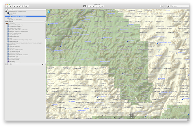
Basecamp 4.8.11 displays a forest of township/range/sheet quadrangle info - line after line after line after line of it, covering the page so densely that the map is unusable. By township/range info I mean, for example, T31S R19E S31, T31S R19E S33, T31S R20E S31, etc, etc, ad nauseam. Lines and lines of this cover the page so densely that it is unusable. This does NOT happen with Basecamp 4.7.0. On a Mac, there is no way to turn off display of this info other than to turn off ALL labels, which is unacceptable.
This occurs with 24K maps, not with the pre-installed 100K maps. I have this problem with the TOPO US 24K SOUTHWEST v3 map (010-C1134-00) and the TOPO US 24K ALASKA ENHANCED (010-C1057-00). which I just purchased from Garmin this week. It presumably occurs with other 24K maps that I own, but I have not tried them.
I spent the better part of an hour with a support person troubleshooting this issue, and he could not resolve it for me.
I would happily switch back to 4.7.0, but it does not run on my current iMac, which is running Catalina 10.15.7.
I have an older MacBook, running Mac OS High Sierra 10.13.6, using Basecamp 4.7.0, and the problem described above is blessedly absent.
-->FIX REQUIRED: THERE HAS TO BE A WAY TO TURN OFF DISPLAY OF TOWNSHIP/RANGE/SHEET QUADRANGLE INFO IN BASECAMP 4.8. The current density of display of this information makes the map in Basecamp UNUSUABLE.
See screenshots below. ALL SCREENSHOTS ARE USING TOPO US 24K SOUTHWEST v3 SD CARD ON OREGON 600T
A: Basecamp 4.8.11 using TOPO US 24K SOUTHWEST v3 SD CARD ON OREGON 600T
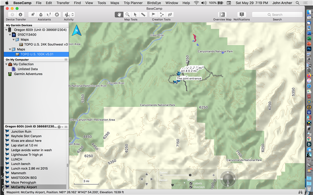
B: Basecamp 4.8.11 using TOPO US 100K V.5.01 (DEFAULT MAP INSTALLED ON OREGON 600T)
C: Basecamp 4.7.0 using TOPO US 24K SOUTHWEST v3 SD CARD ON OREGON 600T
D: Basecamp 4.7.0 using TOPO US 100K V.5.01 (DEFAULT MAP INSTALLED ON OREGON 600T)
Since this form uploads images in extremely low resolution, I have also provided links where these can be seen at full resolution.
===================
A: Basecamp 4.8.11 using TOPO US 24K SOUTHWEST v3 SD CARD ON OREGON 600T
https://www.flickr.com/photos/44693739@N07/51210900787/in/album-72157719302572436/
THIS IS THE PROBLEM THAT NEEDS TO BE FIXED - USING 24K TOPO MAP on 4.8.11
B: Basecamp 4.8.11 using TOPO US 100K V.5.01 (DEFAULT MAP INSTALLED ON OREGON 600T)
https://www.flickr.com/photos/44693739@N07/51210900837/in/album-72157719302572436/
THE PROBLEM DOES NOT OCCUR WITH TOPO 100K USING 4.8.11
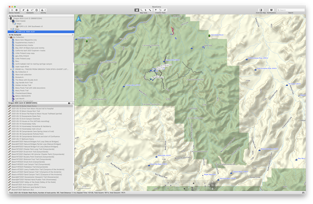
C: Basecamp 4.7.0 using TOPO US 24K SOUTHWEST v3 SD CARD ON OREGON 600T
https://www.flickr.com/photos/44693739@N07/51211611386/in/album-72157719302572436/
THERE IS NO PROBLEM WITH 24K MAPS IN BASECAMP 4.7.0
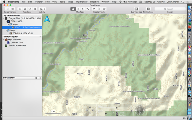
D: Basecamp 4.7.0 using TOPO US 100K V.5.01 (DEFAULT MAP INSTALLED ON OREGON 600T)
https://www.flickr.com/photos/44693739@N07/51211611411/in/album-72157719302572436/
SIMILARLY THERE IS NO PROBLEM WITH 100K MAPS IN 4.7.0.