i downloaded a full set of USM TOPO routable maps, also have the garmin TOPO map package that came on my etrex 35t and regions that i downloaded from openstreet.nl.
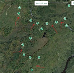
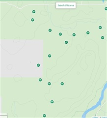
i'm planning a hike in remote area and am noticing that on google maps/satellite images i can see lots of logging roads that are viable for exploring yet no map that i have actually has these identified, examples attached.
one way i've circumvented this by going to garmin connect and making a hand drawn .gpx track based off the google satellite map that they provide that i can then overlay on my etrex. but i was wondering if there's a way that i can take a screen shot of the google map and somehow overlay it on a topo map and combine them all together into an .img or .gmap file? i think i've come across some posts that talked about that but i don't even know what the proper term for this "combination" would be to even search for it online?
can someone please advise whether what i'm talking about is viable?
.