Hi,
I export GoPro GPS data to use it in Virb Edit. Virb does a great job in general, but speeds are between mostly wrong and completely wrong. Calculated speeds only seem decent if the
My trkpts look like this
<trkpt lat="43.25934222222222" lon="13.505879233333333">
    <ele>146.82833333333332</ele>
    <time>2020-03-01T14:36:40.515Z</time>
    <extensions>
        <gpxtpx:TrackPointExtension>
            <gpxtpx:speed>0.23555555555555557</gpxtpx:speed>
        </gpxtpx:TrackPointExtension>
    </extensions>
</trkpt>
And the extension is declared at the top:
<gpx xmlns="http://www.topografix.com/GPX/1/1"
  xmlns:gpxtpx="http://www.garmin.com/xmlschemas/TrackPointExtension/v2" version="1.1" creator="https://github.com/juanirache/gopro-telemetry">
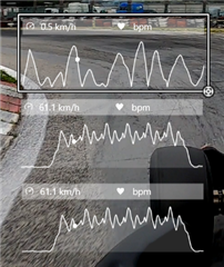
With high frequencies (18Hz) the calculated speeds are between 0.1 and 0.4 km/h instead of the real ~90 km/h. If I convert the file to 1 sample per second calculated speeds get closer to reality, about 75 km/h.
The "recorded speeds" are always absolutely wrong, and they do not change even if I delete the <extensions> section of each trkpt. So Virb Edit is not reading those data at all, just making up some values based on I don't know what.
On top is the "recorded" 3D speed, then calculated 3d and calculated 2d. As you can see, there is absolutely no relation between the "recorded" data and reality, but the fact is the speed recorded in the GPX file is correct.

Does anyone know what's going on?
Thank you

