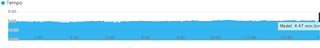
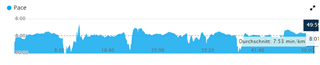
sorry, but again the GPS Update is bad as always, compared to Stryd, here an easy 50min Recovery Run, always same speed, but pace looks horrible compared to Stryd, but when i use Stryd for GPS then Garmin don't calculate vo2max:
Ok, sorry to hear. Unfortunately it seems like your GPS data is rubbish. You might have a bad day but if the pace data always is like that I have no clue as to why. I assume you have synced the watch to download the latest satellite data and waited long enough to get a good and locked GPS signal.
Here is pace data for a easy steady pace run for me in Garmin Connect:
I also used Stryd but I am not sure whether the shown pace is based on GPS or Stryd. Does garmin connect override Stryd pace data with GPS data? If I zoom I see that it takes 3 sec before pace data is recorded. Stryd takes about three seconds to start transmitting data (waking up). So for me it seems like the pace data is based on Stryd in garmin connect and not GPS. But I can be wrong.
Can you overlay GPS pace data and Stryd pace data on the same graph? At least to narrow it down as to where and when the GPS seems to provide bad data. Could it be around tall houses, tree coverage, quick turns, on bridges etc?
Is it the same problem with cadence? Discrepancy in cadence should also be visible. If pace drops it would seem natural to also see cadence drop.
rubbish
yes, everytime with Garmin GPS my pace looks rubbish, thats the reason why i bought Stryd :-\
and i hope i didn't live in a rubbish country (Salzburg) :D
i didn't know how to record both pace fields, mean one with Garmin GPS and one with Stryd pace, i think, i need 2 watches for this, but i haven't
Well, very different experience here... pace is very stable for a stable run. Would never use instant pace, but overall (lap pace) it's fine. But a screenshot like this is quite useless without extra info...
What settings? GPS, GPS+Glonass, GPS+Galileo? For me GPS only works great and in the past adding glonass or galileo could actually make things worse...
Big buildings, mountains, tree covers, etc around? Can all mess up gps
Perhaps if you supply an actual link to the garmin connect activity something usefull can be said...