This discussion has been locked.
You can no longer post new replies to this discussion. If you have a question you can start a new discussion

Turn by Turn help on courses with Edge 530

I need some help with Turn by Turn on the Garmin.

I must be missing something as I have received some GPX files for a Fondo's / Sportive which whether I put them into Garmin Connect or Komoot they do not have turn by turn.

Just blank waypoints every half k or so which becomes super annoying on the journey.

Is the a good practice guide to get a route onto the 530 from a GPX, that it will do the turn by turn on?

Thanks

  • u should get TBT when u load the GPX files into the 530. Why would u expect TBT in connect or komoot - what did u expect to see in connect/Komoot??? Have u used a Garmin GPS edge before?

    Best way to load the GPX file into the 530 is to connect it via the cable to the PC and copy it to the Garmin/New file folder....it'll then appear in your garmin as one of the courses to ride....

  • Yes, but I thought (maybe wrongly) was that you could import the GPX to Garmin Connect and then Sync the course (send to device via the mobile app, I know that Komoot said this will not do turn by turn regardless so I should probably not have referenced this above) to the device and it would pick up turn by turn from there. I'll try the wired version tonight.

  • Maybe, post a link to one of files you are having a problem with.

    You need to make sure "turn guidance" is enabled. It should be in the menu for the courses list (I"m basing that on a 1030. I'm hoping the 530 is similar.

    The "turn guidance" turn instructions (big white arrow) are calculated on the device. There's another type of turn instructions called "course points". These require the file to be either FIT or TCX.

    For "turn guidance", it matter how the GPX file gets to the device as long as it shows up in the course list (this is assuming that the GPX is the right kind of GPX file).

    I'm going to guess that Komoot is talking about getting  "course points" with GPX files. That would make sense (it's the only thing that makes sense).

  • Ok so dropped the GPX file into course on the 530 and this doesn't appear as it seem it only recognises .fit files.

  • You need to drop it into the NewFiles folder so that it gets convert to FIT and moved to the courses folder.

  •  see attached link for .GPX

    https://evans-my.sharepoint.com/:u:/g/personal/mark_gregory_evanscycles_com/EdIKYzcJWUZCpV-Vd26kKUgBlIGEIzL4zPDS9OqFkApmjw?e=WKGcKP

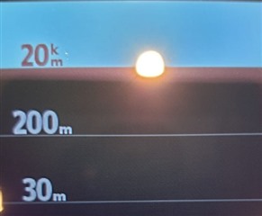
    I get the following view for turn by turn from the gpx.

    20km blnak

    200m blank

    30m blank

    like it is a course point but it should not be it should have completely different instructions.

    I am miles away from this course and if I navigate to the course it picks up the turn by turn to the course. But not on the course itself!

  • Thanks that get it to being in the courses! but same issue arises! - I also get only 50 points can be used for on road navigation! This is so frustrating!

  • That file looks fine.

    "I am miles away from this course and if I navigate to the course it picks up the turn by turn to the course. But not on the course itself!"

    So, you are choosing "Navigate to Start"?

    If so, that just may get you to the start.

    You might need to reload the course to get the "turn guidance" for it.

    (That's what the old 800 did; Not sure about the newer units.)

    I'm not sure what that picture is showing... It's not any turn instructions (turn guidance or course points), it seems.

    ==============

    You might consider creating a short course in your neighborhood and see how that goes.

  • that is exactly the issue if I navigate to start the unit works as intended with turn by turn. But when it get to the course I get the above pick which a is incorrect as you have to do more turns before you get to 20k of an 80k course! and then "instructions" are very regular and annoying! 

    Regarding short course, I cycle to my parents in law and use that as new test run, but I have the same with ever course, even using the Komoot Connect IQ app! I am not sure what to do. The GPX's have now been loaded either via the mobile app or physically loaded.

  • What are you creating the course in?

    If it's RWGPS, download the file and copy it to your unit using a wire (it looks like you are doing that). The Komoot app isn't going to magically make things work. Pick one method and get that to work. Then, worry about using other apps.

    The file you provided looks like it should work. I can't try it because I don't have the map.

    If you are using "Navigate to Start", reload the course again when you get to the start.

    Do you have "Turn Guidance" enabled? Verify that first.

    (I'm not sure how to do that on a 530.)