Distance measuring inaccuracy

Hello,

Last two days I had possibility to test Walk activity on longer distances. While walking I spent some time indoors, I'm pretty sure GPS didn't have enough sky to get satellites. In the end of the trip I get info from Instinct I walked almost 28km. I knew it wast totally not true. Today I exported GPX and opened it in OkMap. I believe this program measures distance in simplest possible way. Result is 16km which is much more reasonable. I wonder where from is this difference which gives all statistics from Garmin into trashbin. I know GPS had problem with signal but I would expect that software would be able to just measure length of track instead of giving totally crazy numbers.
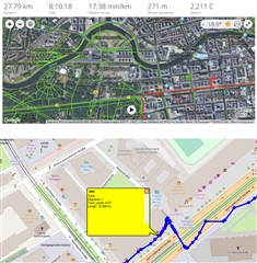
I have to admit, with clear sky in the mountains I didn't experience this issue. But when I walk I don't always remember to pause recording and then run it again and probably it will affect overall time of walk?

What's funny: I had with me Huawei phone, second person had Samsung, both were recording steps only in automatic mode (without GPS) and result was almost identical: 13.5km.

In this case this simple measuring method was the most accurate.

Regards Rafal

  • With a weak GPS signal (i.e. the receiver only receiving signals from a few satellites) triangulation is poor and so a fix may have an accuracy of many meters. It doesn't take much for a few consecutive fixes to create an apparent path that is much further than the actual one. This is usually seen in a wild zig-zagging of the track when viewed on a large scale map.

  • I understand, but this is not what I see on my watch. When I go indoors, even in places where there is absolutely no chance of getting any GPS signal (like in a cellar or a long tunnel) the watch constantly reports last availble speed (which does not change a bit until I go outside) and accumulates distance accordingly. When I later look at the GPS track I can see that in fact there was no GPS signal available, as there are no signs of an apparent path (as you nicely called it). But the extra spurious distance is still there.

  • That would be fine if saved track would be crazy zig-zag. Actually it looks not too bad, still high buildings influence quality of the track. Anyway, in this case problematic for me is Instinct (and Garmin Connect) saying I walked yesterday 28km and when I exported GPX from Garmin Connect and opened in other software from the same data I get 16km.

    I would expect this kind of gear would to measure items mentioned in features of the device. But then I feel I receive info" yes it will measure, but..." and then there is list below:

    -heart-rate sensor gives only general view (this one is mentioned in manual)

    -pedometer quite often gives questionable results

    -altimeter - here some topics with problematic readings (for me in open air it was ok)

    -GPS - my yesterday experience very much disappointed me

  • Based on tmk2's description above, it seems like the Instinct estimates distance when GPS is lost/weak in a reasonable fashion: uses your last reported speed to calculate distance until GPS signal is recovered.  Given that the watch is designed to use GPS for outdoor activities, I find this to be a pretty good solution for your normal outdoor issues (e.g. tunnels, heavy tree cover).  I guess Garmin could use some other algorithm to estimate distance when GPS is lost (e.g. steps), but the current method seems fine for the intended use of the watch.

    I would suggest you just use the fitness tracking function of the Instinct (steps, floors) when you will be doing a city tour with both indoor/outdoor time (or pause your walk when inside).  I didn't realize that there has been any issue with the step counting function, except when you are holding onto something (trekking poles, stroller).  In that case, many fitness trackers could have an issue.  On walks, I find the OHR to be OK, but I think a chest strap is necessary for runs, bike rides, and other more strenuous activities.  The altimeter does seem to smooth changes in descent-ascent, but this is a more pronounced issue on bike rides than for running/hiking/walking.  You do need to keep the altimeter port clean and try to prevent sweat from building up around it.

    So, try to stay positive about the Instinct - it is a pretty darn good outdoor fitness watch.

  • I guess Garmin could use some other algorithm to estimate distance when GPS is lost (e.g. steps), but the current method seems fine for the intended use of the watch.

    It's not fine because it gives very bad results. This would only work when going straight ahead at a constant speed, and that is a rare case. Anyway, both the Instinct and the FR735XT have the ability to track pace indoors using bullt-in accelerometers, and this is how it works when starting an indoor activity, but for some reason does not kick in when using an outdoor profile, although it should in cases when GPS is not available. To make things worse, the footpod is ignored as well, even though there is this option to use it as a pace source when no GPS is available.

  • Thanks for reply and suggestions GeoffR.

    You mentioned to use in city tour activities like steps, floor. These activities work without GPS, is that correct? But I would like to get path after trip is finished. Then I could use second option: to pause activity when I go indoors. There is big disadvantage of this method for me: it's so easy to forget to pause or turn it on again. And also I don't want to think about watch all the time. I would expect rather "fire and forget" idea. To be honest, for me it's a shame that so much dedicated device as Instinct can't handle it well. tmk2 suggested below to auto change distance measuring from GPS to steps, which seems to be good solution. Unfortunately if it's not implemented yet I doubt we will get it in this version of Instinct.

    Generally I'm happy with Instinct. I like it's design, materials and range of features. I just miss few more touches like this measuring issue or better location of pressure sensor/hole.

  • It could be that your datum is not entirely correct. The Garmin default datum is wgs84. Wgs84 is a global datum and While wgs84 is not not correct it may just not be as accurate as a more local datum.  I have recently changed my datum to ordnance survey gb. Maybe find your local datum and see what difference it makes?

  • I do not see how changing datum could help the watch perform better indoors. Datum is completely irrelevant unless you transfer coordinates between different systems (like a paper map and an electronic device) that use different datum.