Dive gps coordinates

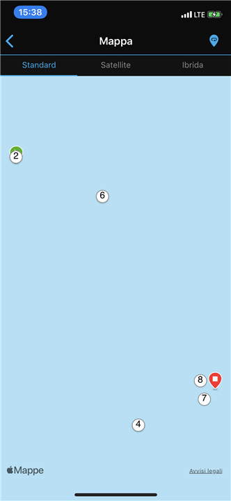
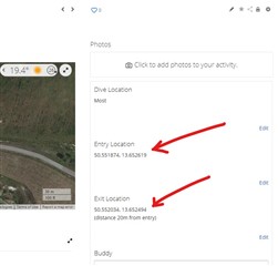
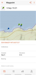
I see where keeps the GPS coordinates on the watch. When I go to view the dive on the Garman app it shows the start and finish, various numbers of dives but no GPS coordinates. Can you only access these through the watch?
Additionally, the watch GPS format does not match my Garman GPS boat plotter. Has any one seen a way to convert those two are usable format?
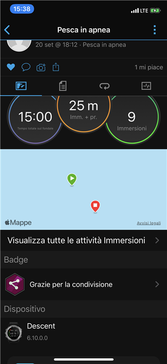
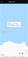
I just got the watch did several good drops free dive spearfishing watch work great. I also tested the capabilities are a couple of tank tops with the Compass that everybody says they have issues. I had no such issues with the Compass freezing.
  • there are a lot of ways to do that - you can go to the logged activity on the watch and save the exit or entry point. then go to navigation activity, in there one of the options are saved locations. Choose the location of interest and it will open menu with several options - on details you can see the exact coordinates. Second option is to do a sync with garmin explore and in the waypoints you can find your saved locations coordinates. The easiest way is to open the garmin connect app on your phone, go to the activity with the location data, open the map and at the bottom you can see the two icons- google maps and got to icon, either way will open a map and display the exact coordinates...
    Also you can directly download from the watch via usb the lctns.fit file with all the saved locations and import it in basecamp, which will be the hardest way i think.

    1. Thank you but I think what you are discussing is related to waypoints while I was talking about the intermidiate positions saved automatically between the different apnea dives. 
      here you can see a session with 9 drives , if I click on the map I can see that the watch has recorded the different positions 

    2. the positions I need are the white circle with numbers and they are not stored as waypoint and they don’t sync with explore or basecamp. I know the watch saves those intermediate positions every time it’s out of the water but again those are not stored as waypoints . 
  • Furthermore I trying with Ggarmin connect on my iPhone and  there is not such Icons at the buttons of the maps. 

  • there is an icon in Android, i guess in iphone is missing. but make sure you click on the icon of the start/end, as the google maps and navigation icons appear only after that. those intermediate points can be saved manually by using the save location functionality, if you want it to be done automatically by the activity you should suggest it to garmin as new functionality. I haven't used it for freediving, so no idea if there is any other way to save them, open the activity and check in the menu if there is something for those stops and saving their coordinates. My guess is if you see them on the map with numbers there certainly should be a way to save them as waypoint/saved location.

  • Open the Activity in Garmin Connect Web. It displays the entry and exit coordinates in clear text. This is an Apnea Activity:

  • Hi Maurizio,

    When I´m spearfishing and I find a good spot I´d like to register in my MK1, what I do is I stick my arm out of the water long enough for the GPS to "acquire signal" (it vibrates when its ready), and then I register it as a waypoint. It is quite fast actually: without leaving the activity, press the bottom left button (down) to get to the map, and then the top right button to select "Save point" or similar, and it will be saved as a waypoint, which you can later review in Garmin Explore like this:

    I only use intermediate apnea points ocasionally (the white circles) and just to have an idea of how my dives were spread out during a certain session. However, these only register in the watch if you stick your arm out of the water long enough each time, so I don´t do it very often. By the way, if you click on these white circles on Garmin Connect you can see the coordinates (they don´t seem to register anywhere else), and at least manually enter them in Explore or any other app:

    Hope this helped!