Elevation problem

Former Member
Former Member

HI

I did read a lot of discussion here:

elevation-consistently-inaccurate-reading-too-low

problem-with-barometric-altimeter

altimeter-issues-in-the-rain

Looks that I am not alone who has problems with elevation. Problem which happen in my case is ONLY during activity. I also think that there are several different problems.

#1

I did check pressure and elevation graph in watch during the day (holding ABC and scroll), values were OK. I did compare pressure with my weatherstation and very close national weatherstation. I did stay at home during all day so altitude was same but elevation in watch change a little (+-5m).

I did start mtb ride at 5:30pm and for 1h ride I did make cca 17km. I did make several small up and down hills. Before I did stop activity I did see that elevation is not correct because I did start and stop almost at same place.

Here are graphs just after I came home:

you can see that elevation at the end is higher. I did start at 228m and stop at 264m.

pressure graph, I was SHOCKED, how pressure can change so much, cca from 1016 to 1022. I did find out that it happen during descent.
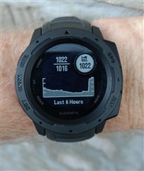
I did check my local weather station:

I also check national weather station, and there is also nothing strange. I did put marks to be able compare with watch 6 hours graph. I think, there is something wrong with sensor or with firmware of Instinct.

I did export activity to GPX and then enable elevation correction in web and export that too. Here is comparison

Blue is original GPX with elevation based on barometer. Green is GPX which has elevation correction enabled.

The significant change start at cca 0.55h = 33min of ride during normal descent.

In other threads someone mentioned sweat can make some problem. And there is also thread where rain is mentioned. Do you think that this can be problem in my case? It is 4 hours after I finish my activity now. Watch still showing wrong values of pressure and elevation. If it is problem of sweat or water then how long it takes to dry? or is it going to correct itself?

#2

What I also know is that instinct is slow in elevation reading.

I can see that in fast descent. Another day I went slower on downhill and also slow down before next uphill. Results was quite OK. Of course, barometric altimeter will not catch all small hills.

Settings:

- altimeter auto cal = off

- barometer watch mode = auto , Tell the true, I don't understand this settings clearly.

thanks for any comments

  • My favourite solution would be (i think) simple: If GPS is on anyway --> Use GPS height

    The GPS accuracy for the altitude is in the range of several tens of meters, so it would result in even much less credible elevation profiles, than the data from the barometric altimeter. Somehow better it could be with the DEM data, but still, especially in accidented terrain, or in urban environment, the resulting profile would not be always better than barometric data. I think the best is keeping the barometric data as they are - you can always turn on the Elevation Correction on the Activity page, to get the elevation data using the DEM topographic data, and then choose whether you trust more the barometric or the topographic version.

  • thanks for your answer

    i can see clearly in my data, that (also with the newest beta) the altimeter data is filtered and also delayed to all gps data and that the gps result stays much more consistent if im recording exactly the same track several days

    --> Alitmeter heights are sometimes differing very very much ... in my case im absolutely sure that GPS is not a super exact solution but clearly the better one

    For example for the same track:

    Day1: alti = 51; GPS = 115

    Day2: alti = 98; GPS = 109

    --> No question that GPS is my choice

    Regarding the option to manually switch to the corrected version:

    - due to the fact, that im connected to Strava & Komoot and the recorded tracks are shared as soon as i press "Safe" on the Watch, the shared GPS data is always with altimeter

    - Im not interested to manually switch settings for each and every activity

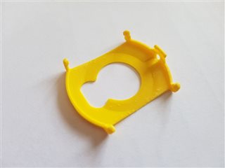
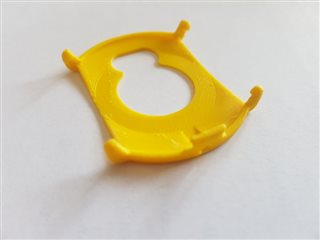
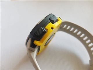
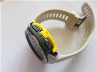
  • I was having elevation issues too, I found this post and printed your guard.  It works really well, my elevation graphs are much smoother.  I printed in PLA and sanded the part that touches my skin down to 240 grit or so, it feels really comfortable.  Thanks for taking the time to make a design and sharing it!

  • Does this device also help with erratic wind induced elevation reporting?  Below: Data from the same bike ride on Hilton Head Island, SC - Flat as a pancake except for a ~100+ high bridge.  First elevation plot is my Instinct.  Second plot is my Edge 530.  The Instinct data is all over the place.  The Edge depicts the elevation very well; even the bridge crossing is very easy to pick out.  I can only assume that the wind generated from the bike velocity caused the Instinct's erratic elevation readings. 

    Instinct:

    Edge 530:

  • Thanks for sharing! I have printed and tested one. It does help preventing sweat or (in biking downhill) skin taping the hole. Of-course it cannot solve the issue from Garmin: the barometer sensor is too slow. It looks after 2 long rides that I have less error on absolute value when giving time for the sensor to keep up but I still find a 5% error on the cumulated elevation (for variations like +600m/h ; -1100m/h). This is associated with the latests software updates + setting the barometer to altimeter + recalibrating the altimeter from GPS regularly during the ride when not near a cliff). Far from perfect, but better than what is was 1 year ago.

  • Hi Thomas, This issue is driving me crazy. I fed up always chasing an answer how to do it, why is happenning etc.

    I will be appreciated if you share this 3D printer file. I would like to buy from the mentioned website but I live in Turkey and it is always problem to get small objects properly. 

    Thanks for your help in advance.

  • Quite annoyed by the smoothness and altimeter issues with the Garmin Instinct. I'm thinking I might actually just return it because it doesn't really seem like Garmin is that interested in fixing the issue considering they put the same design flaw in their $700aud Instinct Solar. Speaking of which, imagine paying $700 for a watch that doesn't have VO2 max, connect IQ or Gpay, and has a fundamental design flaw knowingly built into it. Garmin really has their priorities right on that one.

    My last resort is gonna be to try out the 3d printed cover but I can't seem to find an STL anywhere? Does anyone know how I can message the creator?

    Thanks!

  • Just wear a sweat wristband and place the right hand side of the watch where the sensor is, over the sweatband. This fixes the sweat issue blocking the sensor and fixes the dropouts problem.

    I do this for any recorded activity where I want the altimeter to work correctly.

    If I just do a cardio workout and don't wear the sweatband, the Elevation has lots of blips, sometimes even triggering the storm alert.

    Also, washing the watch, then drying and blowing the water out of the sensor afterwards, can help. 

  • Hi. 
    i am very interested in your barometer cover since i have the same issues with my instinct tactical. 

    I live in sweden and it is to expansive to order the cover from your site.. Could you send me the .stl file so I could print it out myself? 

    big thanks! / Vincent 

    v.hornsten(at)yahoo(dot)se